Approximate Location Map
Large Map »
Latitude: 53.9613 / 53°57'40"N
Longitude: -1.0868 / 1°5'12"W
OS Eastings: 460012
OS Northings: 452072
OS Grid: SE600520
Mapcode National: GBR NQVM.HR
Mapcode Global: WHFC3.8PQL
Plus Code: 9C5WXW67+G7
Entry Name: Multangular Tower and Wall Attached to South East
Listing Date: 14 June 1954
Grade: I
Source: Historic England
Source ID: 1257120
English Heritage Legacy ID: 464203
ID on this website: 101257120
Location: Museum Gardens, York, North Yorkshire, YO1
County: York
Electoral Ward/Division: Guildhall
Parish: Non Civil Parish
Built-Up Area: York
Traditional County: Yorkshire
Lieutenancy Area (Ceremonial County): North Yorkshire
Church of England Parish: York St Michael-le-Belfrey
Church of England Diocese: York
Tagged with: Tower
YORK
SE6052SW MUSEUM GARDENS
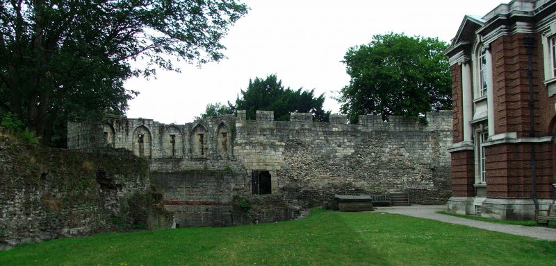
1112-1/27/775 Multangular Tower and wall attached
14/06/54 to south-east
GV I
Defensive tower and length of wall approximately 25 metres
long forming west angle tower and south-west wall of the Roman
legionary fortress of Eboracum; incorporated later into the
defences of the medieval city. c300 AD; tower raised in late
C13; excavated 1831; restored 1960. Roman masonry in small
limestone blocks laced with bonding courses of red tile; tower
raised in larger ashlar blocks. Tower is approximately 9.5
metres high, on battered plinth. Upper stage is faceted, each
of 8 faces having a cruciform arrow slit. At former parapet
level, stub of water spout projects. On inner side slits are
set in pointed arched recesses.
Wall approximately 5.5 metres high and contains a number of
blocked recesses on the inner side.
(An Inventory of the Historical Monuments in the City of York:
RCHME: The Defences: HMSO: 1972-: 110).
Listing NGR: SE6001252072
External links are from the relevant listing authority and, where applicable, Wikidata. Wikidata IDs may be related buildings as well as this specific building. If you want to add or update a link, you will need to do so by editing the Wikidata entry.


Other nearby listed buildings
