Approximate Location Map
Large Map »
Latitude: 53.2585 / 53°15'30"N
Longitude: -1.9188 / 1°55'7"W
OS Eastings: 405513
OS Northings: 373503
OS Grid: SK055735
Mapcode National: GBR HZ1R.CM
Mapcode Global: WHBBS.HCH9
Plus Code: 9C5W735J+CF
Entry Name: Claremont
Listing Date: 31 January 1997
Grade: II
Source: Historic England
Source ID: 1258018
English Heritage Legacy ID: 463201
ID on this website: 101258018
Location: The Park, High Peak, Derbyshire, SK17
County: Derbyshire
District: High Peak
Electoral Ward/Division: Corbar
Parish: Non Civil Parish
Built-Up Area: Buxton
Traditional County: Derbyshire
Lieutenancy Area (Ceremonial County): Derbyshire
Church of England Parish: Buxton with Burbage and King Sterndale
Church of England Diocese: Derby
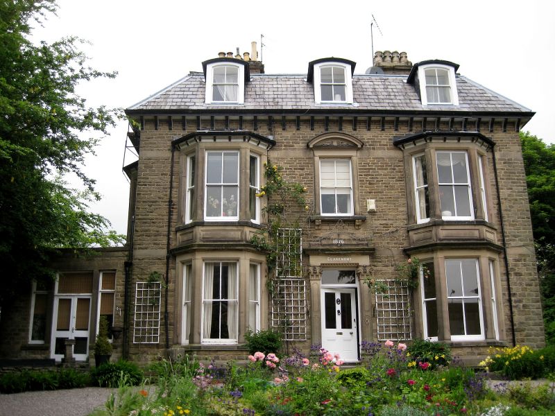
BUXTON
SK07SE ST JOHN'S ROAD
616-1/2/63 (North side)
No.20
Claremont
GV II
House, now flats. 1876, extended 1930 and converted mid C20.
Dressed millstone grit with ashlar dressings and Welsh slate
Mansard roof with stone stacks.
EXTERIOR: 2 storeys and attic. Symmetrical entrance front has
3 windows. Central doorway with part glazed door and overlight
in ashlar surround with 2 Corinthian columns and flat hood
with curved top inscribed 1876. Above a 2/2 sash in moulded
ashlar surround with bracketed sill and segmental pediment.
Either side single 2 storey canted stone bay windows with lead
roofs and 2/2 and plain sashes. Above 3 segment headed dormer
windows each with a 2/2 sash.
Right return has 4 windows arranged 2:2. Left block has 2
sashes to each floor, that to ground floor right has later
stained glass, and above 2 segment headed dormers. Right block
has similar fenestration topped with 2 through eaves gabled
dormer windows.
INTERIOR: not inspected.
Listing NGR: SK0551373503
External links are from the relevant listing authority and, where applicable, Wikidata. Wikidata IDs may be related buildings as well as this specific building. If you want to add or update a link, you will need to do so by editing the Wikidata entry.


Other nearby listed buildings
