Approximate Location Map
Large Map »
Latitude: 51.275 / 51°16'29"N
Longitude: 1.0757 / 1°4'32"E
OS Eastings: 614625
OS Northings: 157364
OS Grid: TR146573
Mapcode National: GBR TY2.W90
Mapcode Global: VHLGM.L6KY
Plus Code: 9F3373FG+X7
Entry Name: Worthgate House
Listing Date: 7 September 1973
Grade: II
Source: Historic England
Source ID: 1258065
English Heritage Legacy ID: 444205
ID on this website: 101258065
Location: Canterbury, Kent, CT1
County: Kent
District: Canterbury
Electoral Ward/Division: Barton
Parish: Non Civil Parish
Built-Up Area: Canterbury
Traditional County: Kent
Lieutenancy Area (Ceremonial County): Kent
Tagged with: House
1.
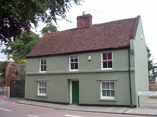
944 WORTHGATE PLACE
(South East Side)
Worthgate House
TR 1457 SE 8/735
II
2.
Early C18. 2 storeys cement-rendered. Tiled roof with 1 central stack. 3 C19
sashes with verticals only. Recessed door with reeded architrave. Door has 6
fielded panels. Rear elevation has 3 casements and 1 hipped dormer.
Listing NGR: TR1462457364
External links are from the relevant listing authority and, where applicable, Wikidata. Wikidata IDs may be related buildings as well as this specific building. If you want to add or update a link, you will need to do so by editing the Wikidata entry.


Other nearby listed buildings
