Approximate Location Map
Large Map »
Latitude: 53.7123 / 53°42'44"N
Longitude: -1.8708 / 1°52'14"W
OS Eastings: 408625
OS Northings: 423994
OS Grid: SE086239
Mapcode National: GBR HTCH.SZ
Mapcode Global: WHC9M.7YDG
Plus Code: 9C5WP46H+WM
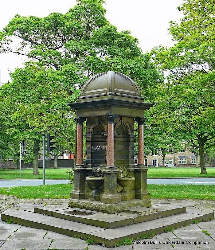
Entry Name: Drinking Fountain
Listing Date: 23 November 1973
Grade: II
Source: Historic England
Source ID: 1258544
English Heritage Legacy ID: 437367
ID on this website: 101258544
Location: Savile Park, King Cross, Calderdale, West Yorkshire, HX1
County: Calderdale
Electoral Ward/Division: Skircoat
Parish: Non Civil Parish
Built-Up Area: Halifax
Traditional County: Yorkshire
Lieutenancy Area (Ceremonial County): West Yorkshire
Church of England Parish: Halifax Holy Trinity and St Judes
Church of England Diocese: Leeds
Tagged with: Drinking fountain
SAVILE PARK
1.
1164
Drinking Fountain
SE 02 SE 7/159
II
2.
Dated 1869. By L Gill. Stone pier with niches to each of 4 faces and shafts
of polished pink granite at angles. Domed top with finials. Presented by
Joseph Thorp. Included as a feature in Park.
Listing NGR: SE0906925516
External links are from the relevant listing authority and, where applicable, Wikidata. Wikidata IDs may be related buildings as well as this specific building. If you want to add or update a link, you will need to do so by editing the Wikidata entry.


Other nearby listed buildings
