Approximate Location Map
Large Map »
Latitude: 52.7725 / 52°46'21"N
Longitude: -2.052 / 2°3'7"W
OS Eastings: 396587
OS Northings: 319437
OS Grid: SJ965194
Mapcode National: GBR 28Q.40Z
Mapcode Global: WHBF1.GK2W
Plus Code: 9C4VQWFX+25
Entry Name: Bank Top Farmhouse
Listing Date: 16 November 1976
Grade: II
Source: Historic England
Source ID: 1258545
English Heritage Legacy ID: 445181
ID on this website: 101258545
Location: Brocton, Stafford, Staffordshire, ST17
County: Staffordshire
District: Stafford
Civil Parish: Brocton
Built-Up Area: Brocton
Traditional County: Staffordshire
Lieutenancy Area (Ceremonial County): Staffordshire
Church of England Parish: Berkswich Holy Trinity
Church of England Diocese: Lichfield
Tagged with: Farmhouse
BROCTON SAWPIT LANE
-----------
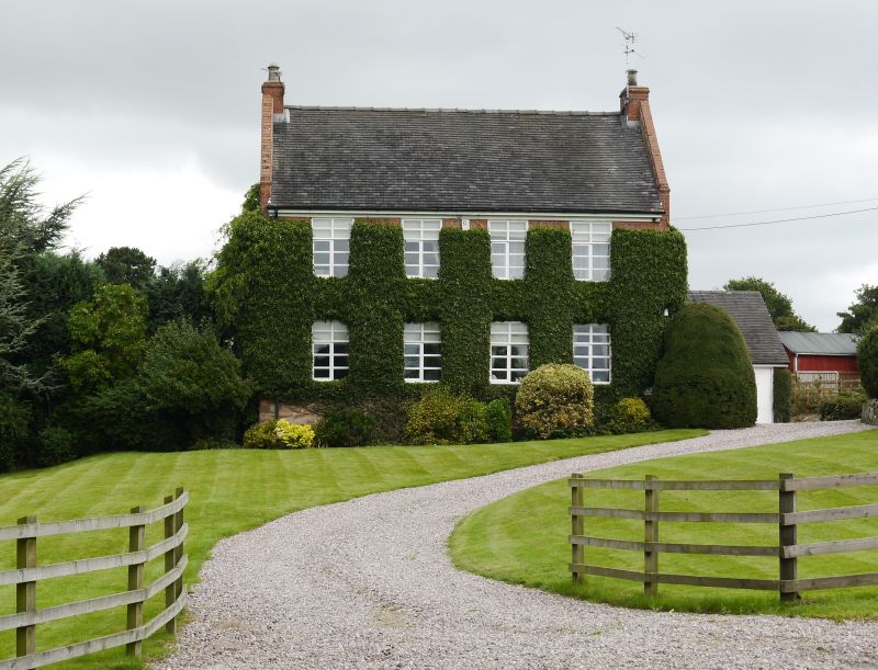
1. Bank Top Farmhouse
2385
SJ 91 NT 15/7
II
2.
Early C18 or possibly late Cl7 origin. A T plan farmhouse of 2 storeys, brick on
an ashlar sandstone plinth. The rear wing contains the staircase and service
accommodation. Gable end old tile roof, coped gable ends with brick chimney
stacks. Band between storeys. 4 window south front, modern wood mullion tran-
somed casement but retaining old furniture. Cambered, gauged brick arched,
casements to rear wing. Internally the main south range is divided into 2 bays
by timber stud partitions with a large open, stone surround, firepiace on the east
wall. The ground and 1st floor rooms to the south west are fully panelled in oak,
mitred rail and muntin type of late C17 date perhaps and partly reset. These are
also substantial sections of panelling in the south east 1st floor room and reset
panels to the ground and 1st floors of the staircase. The latter is late Cl7 or
early C18 solid string with turned balusters, square capped newel posts, dog leg
runs.
Listing NGR: SJ9658719437
External links are from the relevant listing authority and, where applicable, Wikidata. Wikidata IDs may be related buildings as well as this specific building. If you want to add or update a link, you will need to do so by editing the Wikidata entry.


Other nearby listed buildings
