Approximate Location Map
Large Map »
Latitude: 51.0661 / 51°3'58"N
Longitude: -1.7902 / 1°47'24"W
OS Eastings: 414798
OS Northings: 129664
OS Grid: SU147296
Mapcode National: GBR 51F.472
Mapcode Global: FRA 7649.GDT
Plus Code: 9C3W3685+CW
Entry Name: 54, St Ann Street
Listing Date: 28 February 1952
Last Amended: 26 January 1977
Grade: II*
Source: Historic England
Source ID: 1258869
English Heritage Legacy ID: 445781
ID on this website: 101258869
Location: The Friary, Wiltshire, SP1
County: Wiltshire
Civil Parish: Salisbury
Built-Up Area: Salisbury
Traditional County: Wiltshire
Lieutenancy Area (Ceremonial County): Wiltshire
Church of England Parish: Salisbury St Martin
Church of England Diocese: Salisbury
Tagged with: Building
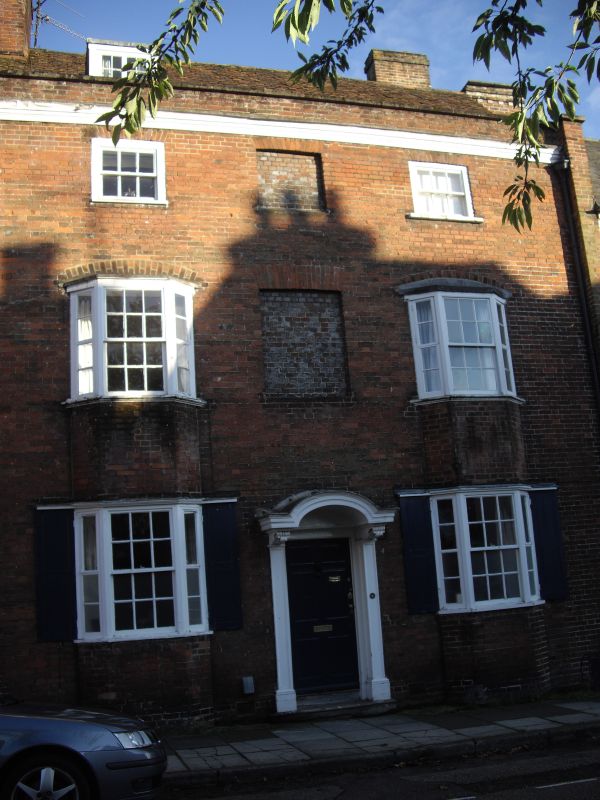
ST ANNE'S STREET
1.
1594 (South Side)
No 54
SU 1429 NE 4/170 28.2.52.
II* GV
2.
C18. 3-storey, brick with 2 flanking, projecting brick piers carried up to
top of parapet. Small moulded wood cornice between piers over 2nd floor windows,
brick parapet with stone coping 2 square windows and central - vitreous brick
panel 2nd floor.
2 shallow brick 2 storey bay windows with segmental relieving arches over small
cornice gutters and lead flats. 1st floor windows have moulded stone cills.
Ground floor windows in bays have small moulded cornice over and foulding shutters
- each leaf 2 flush panels. Centre window of bays 3 panes wide, side windows
- 1 pare. Small vitreous brick panel between bays at lst floor level.
Centre doorway - 6 flush panelled door, plain surround flanked by panelled
pilasters with same panelling in reveals of door. Richly carved acanthus scroll
brackets with egg and tongue mould carried round, flat moulded hood with open
curved pediment in centre.
Interior has staircase with open string, moulded balusters, moulded newels
and handrail.
Nos 44 to 74 (even) and Nos 78 to 82 (even) form a group.
Listing NGR: SU1479829664
External links are from the relevant listing authority and, where applicable, Wikidata. Wikidata IDs may be related buildings as well as this specific building. If you want to add or update a link, you will need to do so by editing the Wikidata entry.


Other nearby listed buildings
