Approximate Location Map
Large Map »
Latitude: 53.8545 / 53°51'16"N
Longitude: -2.2105 / 2°12'37"W
OS Eastings: 386252
OS Northings: 439825
OS Grid: SD862398
Mapcode National: GBR FR0W.70
Mapcode Global: WHB7R.0CPY
Plus Code: 9C5VVQ3Q+QR
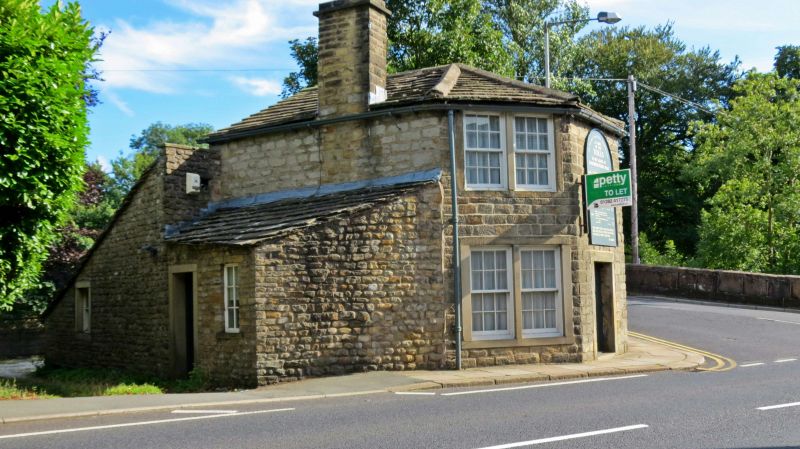
Entry Name: Toll House
Listing Date: 28 June 1968
Grade: II
Source: Historic England
Source ID: 1259044
English Heritage Legacy ID: 186180
ID on this website: 101259044
Location: Barrowford, Pendle, Lancashire, BB9
County: Lancashire
District: Pendle
Civil Parish: Barrowford
Built-Up Area: Barrowford
Traditional County: Lancashire
Lieutenancy Area (Ceremonial County): Lancashire
Church of England Parish: Barrowford St Thomas
Church of England Diocese: Blackburn
SD 8639 NW BARROWFORD GISBURN ROAD
(east side)
16/45 Toll House
28.6.68
GV II
Early C19. Stone. Stone slate roof. 2 storeys. Canted front has doorway with
plain surround opposite corner of road, and a 2-light window to each floor in each
of the facets, retaining sashes except to the ground floor facing south.
Listing NGR: SD8625239825
External links are from the relevant listing authority and, where applicable, Wikidata. Wikidata IDs may be related buildings as well as this specific building. If you want to add or update a link, you will need to do so by editing the Wikidata entry.


Other nearby listed buildings
