Approximate Location Map
Large Map »
Latitude: 51.283 / 51°16'58"N
Longitude: 1.0839 / 1°5'2"E
OS Eastings: 615156
OS Northings: 158280
OS Grid: TR151582
Mapcode National: GBR TY2.JTV
Mapcode Global: VHLGM.Q0WS
Plus Code: 9F3373MM+6H
Entry Name: The Haven
Listing Date: 7 September 1973
Grade: II
Source: Historic England
Source ID: 1260240
English Heritage Legacy ID: 441189
ID on this website: 101260240
Location: Northgate, Canterbury, Kent, CT1
County: Kent
District: Canterbury
Electoral Ward/Division: Northgate
Parish: Non Civil Parish
Built-Up Area: Canterbury
Traditional County: Kent
Lieutenancy Area (Ceremonial County): Kent
Tagged with: Architectural structure
1.
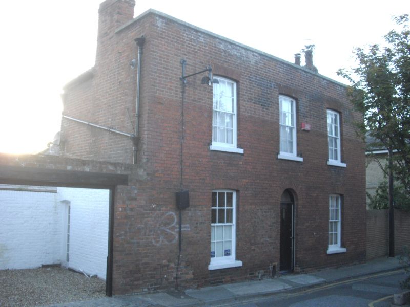
944 ST JOHN'S PLACE
No 10 (The Haven)
TR 1558 SW 3/664
II
2.
Early C19. 2 storeys red brick. Hipped tiled roof with stone coping. 2
cambered sashes and 1 blank, with stone cills and glazing bars intact. Round-headed
doorcase.
Listing NGR: TR1515358282
External links are from the relevant listing authority and, where applicable, Wikidata. Wikidata IDs may be related buildings as well as this specific building. If you want to add or update a link, you will need to do so by editing the Wikidata entry.


Other nearby listed buildings
