Approximate Location Map
Large Map »
Latitude: 51.7452 / 51°44'42"N
Longitude: -2.2106 / 2°12'37"W
OS Eastings: 385559
OS Northings: 205184
OS Grid: SO855051
Mapcode National: GBR 1MK.KYD
Mapcode Global: VH94Y.MDQH
Plus Code: 9C3VPQWQ+3Q
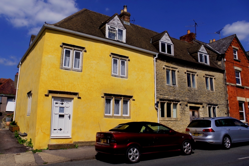
Entry Name: 21 and 23, Parliament Street
Listing Date: 25 June 1974
Grade: II
Source: Historic England
Source ID: 1262156
English Heritage Legacy ID: 435705
ID on this website: 101262156
Location: Stroud Hill, Stroud, Gloucestershire, GL5
County: Gloucestershire
District: Stroud
Civil Parish: Stroud
Built-Up Area: Stroud
Traditional County: Gloucestershire
Lieutenancy Area (Ceremonial County): Gloucestershire
Church of England Parish: Stroud Holy Trinity
Church of England Diocese: Gloucester
Tagged with: Building
1. PARLIAMENT STREET
(North Side)
Nos 21& 23
SO 8505 5/39
II
2
C17/C18. Coursed rubble. Modern pitched roof. 2 storeys and attics. 5 ranges
of mullioned windows with hoodmoulds. 2 planked doors.
Listing NGR: SO8555905184
External links are from the relevant listing authority and, where applicable, Wikidata. Wikidata IDs may be related buildings as well as this specific building. If you want to add or update a link, you will need to do so by editing the Wikidata entry.


Other nearby listed buildings
