Approximate Location Map
Large Map »
Latitude: 51.2265 / 51°13'35"N
Longitude: 1.4041 / 1°24'14"E
OS Eastings: 637772
OS Northings: 152989
OS Grid: TR377529
Mapcode National: GBR X1Y.1TF
Mapcode Global: VHMDG.9F4L
Plus Code: 9F336CG3+JJ
Entry Name: 14, Coppin Street
Listing Date: 8 February 1974
Grade: II
Source: Historic England
Source ID: 1262761
English Heritage Legacy ID: 177040
ID on this website: 101262761
Location: Deal, Dover, Kent, CT14
County: Kent
District: Dover
Civil Parish: Deal
Built-Up Area: Deal
Traditional County: Kent
Lieutenancy Area (Ceremonial County): Kent
Tagged with: Building
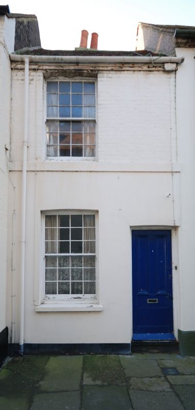
COPPIN STREET
1.
1035
(South Side)
No l4
TR 3752 NE 1/71C
II GV
2.
Early C19. 2 storeys and basement painted brick. Old tiled roof. 2 sashes
with glazing bars intact on 1st floor only. Right side doorcase with entablature,
pilasters and 6 panelled door, the top 2 panels cut away and glazed. 3 steps
to street.
Nos 13 and 14 form a group together with No 127 Beach Street.
Listing NGR: TR3777252989
External links are from the relevant listing authority and, where applicable, Wikidata. Wikidata IDs may be related buildings as well as this specific building. If you want to add or update a link, you will need to do so by editing the Wikidata entry.


Other nearby listed buildings
