Approximate Location Map
Large Map »
Latitude: 51.3525 / 51°21'9"N
Longitude: -1.9928 / 1°59'34"W
OS Eastings: 400594
OS Northings: 161493
OS Grid: SU005614
Mapcode National: GBR 2V1.10T
Mapcode Global: VHB4G.D8TH
Plus Code: 9C3W9234+2V
Entry Name: 2, Maryport Street
Listing Date: 19 September 1972
Grade: II
Source: Historic England
Source ID: 1263033
English Heritage Legacy ID: 433367
ID on this website: 101263033
Location: Devizes, Wiltshire, SN10
County: Wiltshire
Civil Parish: Devizes
Built-Up Area: Devizes
Traditional County: Wiltshire
Lieutenancy Area (Ceremonial County): Wiltshire
Church of England Parish: Devizes St John
Church of England Diocese: Salisbury
Tagged with: Building
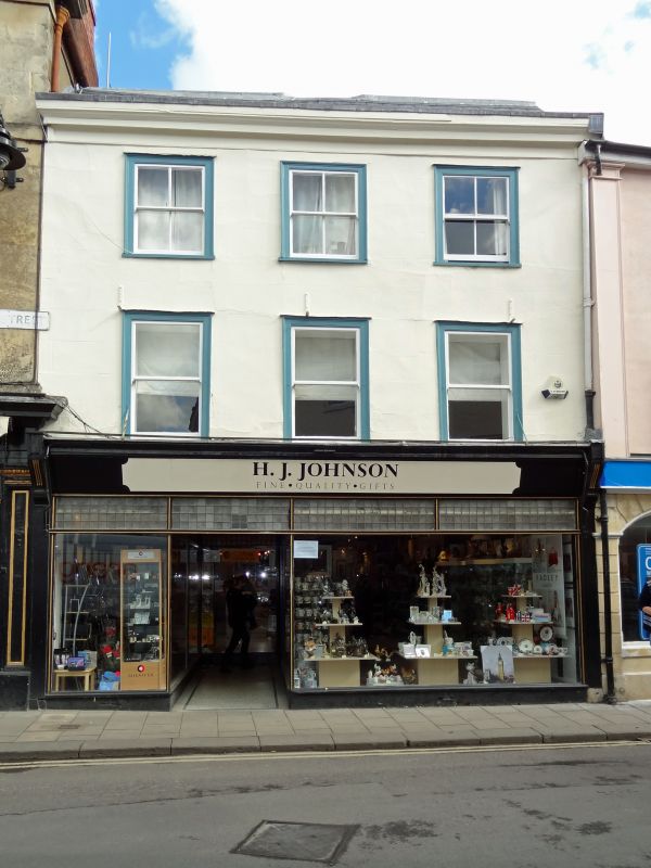
1.
1042 MARYPORT STREET
(East Side)
No 2
SU 0061 3a/269
II GV
2.
Late C18 altered. 3 storeys painted stone. Shallow frieze and moulded wood
eaves cornice. Gable end slate roof. 3 windows to upper floors, sash, later
glazing bars, moulded flush wood frames, thin block sills. Ground floor has
early C20 shop front.
Nos 1 to 16 (consec) form a group.
Listing NGR: SU0059461493
External links are from the relevant listing authority and, where applicable, Wikidata. Wikidata IDs may be related buildings as well as this specific building. If you want to add or update a link, you will need to do so by editing the Wikidata entry.


Other nearby listed buildings
