Approximate Location Map
Large Map »
Latitude: 51.5092 / 51°30'33"N
Longitude: -0.1267 / 0°7'36"W
OS Eastings: 530097
OS Northings: 180579
OS Grid: TQ300805
Mapcode National: GBR HF.Q5
Mapcode Global: VHGQZ.RBCD
Plus Code: 9C3XGV5F+M8
Entry Name: St Martin's Vicarage
Listing Date: 5 February 1970
Grade: II*
Source: Historic England
Source ID: 1264791
English Heritage Legacy ID: 426933
ID on this website: 101264791
Location: London, Westminster, London, WC2N
County: London
District: City of Westminster
Electoral Ward/Division: St James's
Parish: Non Civil Parish
Built-Up Area: City of Westminster
Traditional County: Middlesex
Lieutenancy Area (Ceremonial County): Greater London
Church of England Parish: St Martin-in-the-Fields
Church of England Diocese: London
Tagged with: Clergy house
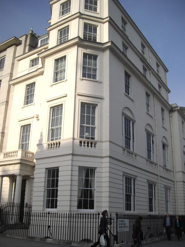
TQ 3080 NW CITY OF WESTMINSTER ST. MARTIN'S LANE, WC2
72/127
5.2.70 No.6 (St Martin's
Vicarage)
G.V. II*
End of terrace town house. c.1827-30 (with mid C.19 attic storey), built
as St. Martin's Vicarage and probably to a design by Nash. Stucco, slate
roof. Entrance front to west, the side elevation related to Vestry Hall
facade and part of Nash's isolation of St. Martin's and the Strand
Improvements. 5 storeys and basement. West front has full height canted
bay of 3 window and single window over entrance; 3-window wide return.
Channelled ground floor. Doric column porch to left with balustraded
parapet. Recessed glazing bar sashes in shallow moulded architraves,those
on 1st floor with cornices over. Pseudo-pedestal to 1st floor with
balustrading in front of windows; projecting cornice over 3rd floor and
attic cornice with blocking course. Cornices etc. returned to south side
which has architraved tripartite glazing bar sashes of same design as those
on Vestry Hall. Cast iron spear and mace head area railings. Part of
St. Martin's Parochial Buildings ; a typically varied Nash composition.
Survey of London; Vol. XX.
Listing NGR: TQ3009780579
External links are from the relevant listing authority and, where applicable, Wikidata. Wikidata IDs may be related buildings as well as this specific building. If you want to add or update a link, you will need to do so by editing the Wikidata entry.


Other nearby listed buildings
