Approximate Location Map
Large Map »
Latitude: 51.5523 / 51°33'8"N
Longitude: -0.0519 / 0°3'6"W
OS Eastings: 535159
OS Northings: 185508
OS Grid: TQ351855
Mapcode National: GBR J6.X5S
Mapcode Global: VHGQV.17WV
Plus Code: 9C3XHW2X+W6
Entry Name: United Reformed Church
Listing Date: 7 May 1974
Grade: II*
Source: Historic England
Source ID: 1265632
English Heritage Legacy ID: 424399
Also known as: The Round Chapel
ID on this website: 101265632
Location: Lower Clapton, Hackney, London, E5
County: London
District: Hackney
Electoral Ward/Division: Lea Bridge
Parish: Non Civil Parish
Built-Up Area: Hackney
Traditional County: Middlesex
Lieutenancy Area (Ceremonial County): Greater London
Church of England Parish: St John at Hackney
Church of England Diocese: London
Tagged with: Church building
This list entry was subject to a Minor Amendment on 05/10/2012
TQ 3585 20/337
5013
7.5.74
LOWER CLAPTON ROAD E5
(South-East Side)
United Reformed Church
GV
II*
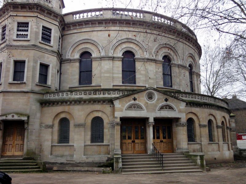
1869-71 by H Fuller. Large 2-storey building of ashlar stonework in Italian style with round-arched windows and much arcading. Wide, rounded west end with projecting ground floor and balustraded parapet. 4-stage octagonal towers, with conical slated roofs, flank the east end: and 2 similar smaller towers flank the western curve. 4 flights of steps radiate from curve and towers. 4-bay returns have full height arcading. Raised attic with round windows.
Interior with continuous gallery to 3 sides supported on cast iron columns, which also support an upper tier of taller columns rising to a continuous cast iron arcade with openwork cast iron spandrels. Round headed archway with Corinthian columns to east end. Contemporary pulpit with double flight of stairs, organ and organ case to east end and timber pews.
The United Reformed Church and the Sunday School form a group with No 1A Glenarm Road.
Listing NGR: TQ3515985508
External links are from the relevant listing authority and, where applicable, Wikidata. Wikidata IDs may be related buildings as well as this specific building. If you want to add or update a link, you will need to do so by editing the Wikidata entry.


Other nearby listed buildings
