Approximate Location Map
Large Map »
Latitude: 51.458 / 51°27'28"N
Longitude: -2.1121 / 2°6'43"W
OS Eastings: 392304
OS Northings: 173225
OS Grid: ST923732
Mapcode National: GBR 2SJ.DV2
Mapcode Global: VH96C.BMR6
Plus Code: 9C3VFV5Q+54
Entry Name: Row of 5 Chest Tombs Approximately 2 Metres to East of Church of St Andrew
Listing Date: 16 September 1997
Grade: II
Source: Historic England
Source ID: 1267992
English Heritage Legacy ID: 462341
ID on this website: 101267992
Location: St Andrew's Church, Chippenham, Wiltshire, SN15
County: Wiltshire
Civil Parish: Chippenham
Built-Up Area: Chippenham
Traditional County: Wiltshire
Lieutenancy Area (Ceremonial County): Wiltshire
Church of England Parish: Chippenham with Tytherton Lucas
Church of England Diocese: Bristol
Tagged with: Chest tomb
CHIPPENHAM
ST9273SW MARKET PLACE
930-1/10/126 (East side)
Row of 5 chest tombs approximately
2m to east of Church of St Andrew
GV II
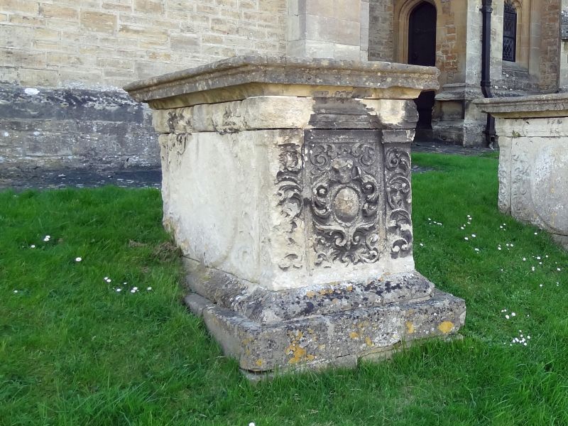
Row of 5 chest tombs close to the east wall of the chancel.
Late C18.
i) Approx 4m from the south-east corner of the chancel.
Cyma-moulded flat top with cornice and entablature, fluted
pilasters articulating 2 ogee-based shields with foliate tops
to the sides, a shield to the west end and scrolled carving to
the east end.
ii) Approx 2m from the east wall of the chancel. One date,
1792 is legible. Plinth; stepped barrel top with a reeded
edge; recessed oval panels, those to the sides with foliate
spandrels; reeded rounded corners.
iii) Approx 2m from the east wall of the chancel. Flat moulded
top; raised oval panels to sides, ogee-based shield to the
west end and a small domed vertical oval framed in scroll
carving to the east end.
iv) Approx 2m to east of north corner of the chancel. Similar
to (iii) above, with an oval panel to the east end.
v) Approx 4m to the north-east of the chancel. Similar to
(iii) above, with a plain west end.
Listing NGR: ST9230473225
External links are from the relevant listing authority and, where applicable, Wikidata. Wikidata IDs may be related buildings as well as this specific building. If you want to add or update a link, you will need to do so by editing the Wikidata entry.


Other nearby listed buildings
