Approximate Location Map
Large Map »
Latitude: 51.4589 / 51°27'32"N
Longitude: -2.1158 / 2°6'56"W
OS Eastings: 392052
OS Northings: 173336
OS Grid: ST920733
Mapcode National: GBR 1R5.KWX
Mapcode Global: VH96C.8LTF
Plus Code: 9C3VFV5M+HM
Entry Name: Lloyds Bank
Listing Date: 22 June 1978
Grade: II
Source: Historic England
Source ID: 1268111
English Heritage Legacy ID: 462249
ID on this website: 101268111
Location: Chippenham, Wiltshire, SN15
County: Wiltshire
Civil Parish: Chippenham
Built-Up Area: Chippenham
Traditional County: Wiltshire
Lieutenancy Area (Ceremonial County): Wiltshire
Church of England Parish: Chippenham with Tytherton Lucas
Church of England Diocese: Bristol
Tagged with: Bank building
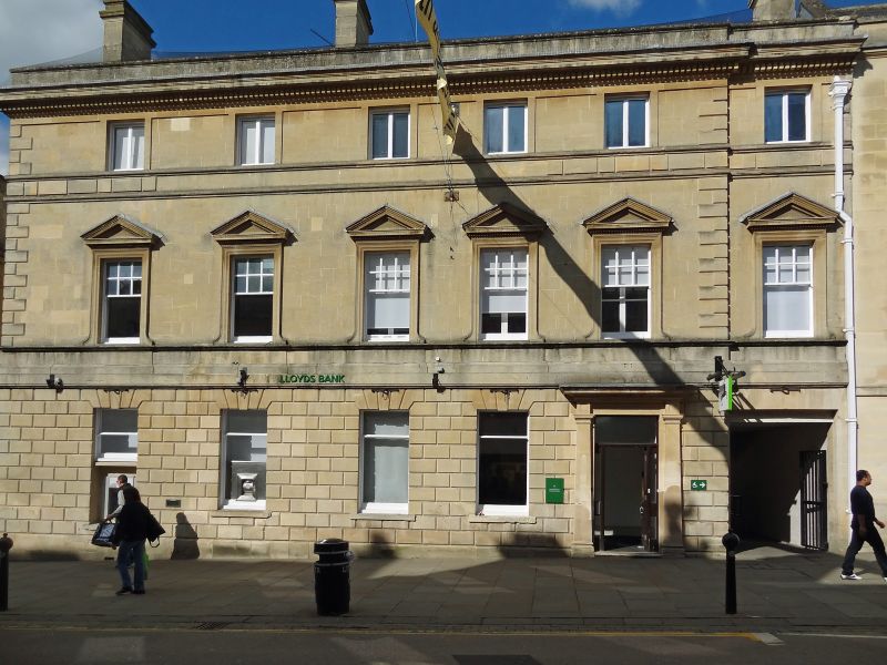
CHIPPENHAM
ST9273SW HIGH STREET
930-1/10/52 (North side)
22/06/78 No.29
Lloyds Bank
II
Bank. c1870. Limestone ashlar, slate roof with coped gables
and moulded ashlar stacks to left of ridge and left gable end.
Classical, mainly Palladian-influenced style. Double-depth
plan with rear extensions.
EXTERIOR: 3 storeys; 6-window range. The right-hand range is
stepped slightly back over a flat-arched carriage entrance
with C20 iron gates. Dentilled cornice and parapet; C20
2-light casement windows to the 2nd floor; 2 moulded string
courses, one at sill level; pedimented horned 6/6-pane sash
windows with dentilled cornices to shouldered architraves and
sill string course to the 1st floor; wide platband over
chamfered rustication to the ground floor; chamfered voussoirs
to C20 windows; Tuscan doorcase with flat pilasters and
cornice to a C20 door.
INTERIOR: not inspected.
HISTORY: in 1914 Lloyd's Bank took over the Wilts and Dorset
Bank and in 1918 the Capital and Counties Bank consolidated
them in this building.
(Chamberlain, Joseph A: Chippenham: Chippenham: 1976-: 112;
The Buildings of England: Pevsner N & Cherry B: Wiltshire:
London: 1967-1975: 172).
Listing NGR: ST9205873347
External links are from the relevant listing authority and, where applicable, Wikidata. Wikidata IDs may be related buildings as well as this specific building. If you want to add or update a link, you will need to do so by editing the Wikidata entry.


Other nearby listed buildings
