Approximate Location Map
Large Map »
Latitude: 53.3363 / 53°20'10"N
Longitude: -2.871 / 2°52'15"W
OS Eastings: 342097
OS Northings: 382509
OS Grid: SJ420825
Mapcode National: GBR 8YDV.7R
Mapcode Global: WH87N.WD1N
Plus Code: 9C5V84PH+GH
Entry Name: E Shaped Range of Farm Buildings to the East of Speke Hall
Listing Date: 15 October 1996
Grade: II
Source: Historic England
Source ID: 1268127
English Heritage Legacy ID: 462221
ID on this website: 101268127
Location: Liverpool, Merseyside, L24
County: Liverpool
Electoral Ward/Division: Speke-Garston
Parish: Non Civil Parish
Built-Up Area: Liverpool
Traditional County: Lancashire
Lieutenancy Area (Ceremonial County): Merseyside
Church of England Parish: Speke St Aidan
Church of England Diocese: Liverpool
Tagged with: Building
SJ48SW SPEKE HALL ROAD
Speke
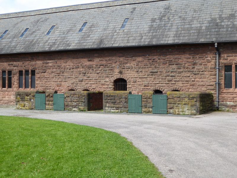
392- 110/10043 E-shaped range of farm buildings
to the east of Speke Hall
GV II
Range of farm outbuildings. Late C19, with minor C20 alterations, and the demolition of roofs to a covered cattle yard following a fire. Snecked, rock-faced red sandstone and plain red brick, some rendered, beneath slated roofs with oversailing eaves and verges and full-length ridge ventilators. E-shaped plan, with the spine range running east-west, parallel to the access track, and with 3 parallel ranges extending southwards to enclose 2 cattle yards, one formerly covered. SPINE RANGE, north elevation: 13 bays, arranged 1:5:1:5:1, with advanced gables to end and centre. T o the left of the centre gable, a 5-bay open fronted cart lodge, with shallow arches supported on cast-iron columns set on low stone piers. East gable with arched doorway, and blocked loft door above. Centre gable with arched double door and tall loft doorway with sloping cill. Further right, a wide archway with substantial spur stones leads into the western yard. To right of archway, 4 bays with paired breathers, and west gable with arched double doorway with boarded doors and loft doorway above. WEST WING: west elevation with 2 and 3-light mullioned windows, south gable with twin doors and loft door above, and east elevation with 2 and 3-light mullioned windows and off-centre doorway. CENTRAL WING: east elevation with archway leading to eastern yard, and then 3 doorways with 2-light mullioned windows between. Above left-hand doorway, a gabled loft doorway with boarded door. Off-centre octagonal chimney serves smithy hearth to centre of wing. South gable with twin doorways and loft door above. East elevation, brick wall with 2 2-light mullioned windows and 2 doors. EAST WING: west elevation now rendered, south gable with centre doorway with loft door above, east elevation with arched double doorway at south end, 2 3-light mullioned windows and range of 4 pig sties, arranged in pairs with low enclosure walls, low entries into pens, and a taller arched feed passage. Former covered yard area enclosed by centre and east wings indicated by former roof valley girder supported on 3 tapering cast iron columns to centre and stone corbels to inward facing corners to central and east wing gables. In-situ feeding troughs remain. INTERIORS: much altered, with most fittings removed. Smithy to central wing with timber baffle, smithy hearth with bellows recess and wide chimney with arched recess. The doorways with sliding door gear set within reveals. Some surviving lineshafting, and one fixed feed chopping machine to loft of central wing. An architecturally distinctive and well detailed range of 'model' farm buildings, incorporating the remains of a covered yard, and with surviving smithy hearth, chimney, together with integral cart lodge and pig sties. It is an important part of the C19 development of the Speke Hall Estate, and demonstrates then current theories of livestock husbandry, and integrated farm building design.
Listing NGR: SJ4209782509
External links are from the relevant listing authority and, where applicable, Wikidata. Wikidata IDs may be related buildings as well as this specific building. If you want to add or update a link, you will need to do so by editing the Wikidata entry.


Other nearby listed buildings
