Approximate Location Map
Large Map »
Latitude: 53.4023 / 53°24'8"N
Longitude: -2.9853 / 2°59'7"W
OS Eastings: 334586
OS Northings: 389952
OS Grid: SJ345899
Mapcode National: GBR 74Q.7B
Mapcode Global: WH877.3RP2
Plus Code: 9C5VC227+WV
Entry Name: Warehouse
Listing Date: 8 October 1996
Grade: II
Source: Historic England
Source ID: 1268259
English Heritage Legacy ID: 462020
ID on this website: 101268259
Location: Liverpool, Merseyside, L1
County: Liverpool
Electoral Ward/Division: Riverside
Parish: Non Civil Parish
Built-Up Area: Liverpool
Traditional County: Lancashire
Lieutenancy Area (Ceremonial County): Merseyside
Church of England Parish: St Luke in the City Team
Church of England Diocese: Liverpool
Tagged with: Warehouse
SJ 3489 DUKE STREET LANE
(east side)
392-/30/10035 Warehouse
II
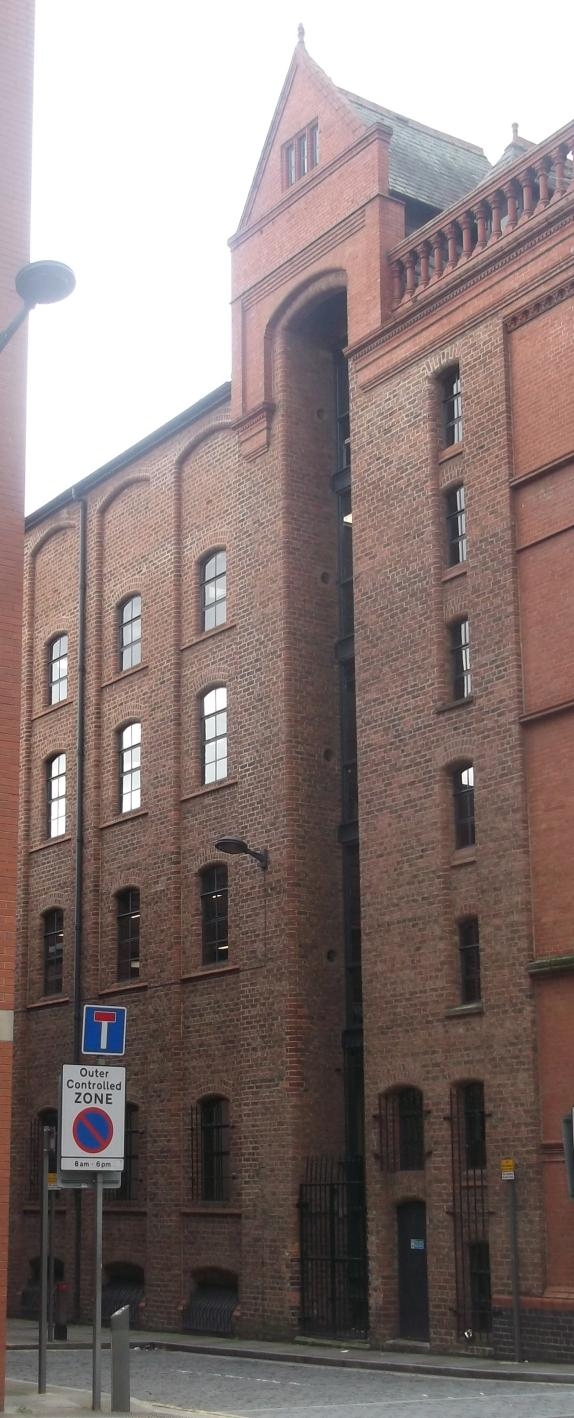
Warehouse. Unoccupied at time of inspection (05/96). Dated 1863 on hoist housing, but possibly earlier and with minor C20 alterations. Red brick with a slated roof covering. Narrow-bodied warehouse , 5 bays deep,extending eastwards. Front (west) elevation: 3 storeys and attic. Tall gable to street frontage with recessed centre beneath a semi-circular arched head within the gable apex. The recessed area shelters tiered pairs of loading doors and landings supported on cast iron beams. At the arch head, a hoist pulley system housed within a gabled metal canopy which bears the date 1863. Flanking the recess are advanced bays with stacked, barred window openings set beneath shallow segmental arches, and with simple brick sills. The windows diminish in height at the higher floor levels. Doorway to left gives access to internal staircase. INTERIOR: heavy timber beams between the side walls are supported by cast-iron columns. The beams carry closely-spaced floor joists. Metal spiral stair located in north-west corner gives access to all floors. HISTORY: Duke Street Lane is situated close to the site of the first enclosed dock in the world, and within the earliest part of Liverpool to be developed for commercial purposes in relation to the port. The area was fully developed by the 1780's, and the present street pattern was established by 1810. The ongoing development of warehousing as a specialist building type was of particular significance in this area of Liverpool, a C19 port of international significance. The warehousing, of which the Duke Street Lane building is an example, represents one of the most important surviving populations of C19 warehousing nationally, and represents the development of the building type from the late C18 to the early C20. This example is a near-intact example of mid C19 date and displays important developmental characteristics such as the use of cast iron columns for internal support, the recessed loading bay, and the enclosed hoist housing.
Listing NGR: SJ3458689952
External links are from the relevant listing authority and, where applicable, Wikidata. Wikidata IDs may be related buildings as well as this specific building. If you want to add or update a link, you will need to do so by editing the Wikidata entry.


Other nearby listed buildings
