Approximate Location Map
Large Map »
Latitude: 53.0091 / 53°0'32"N
Longitude: -1.4924 / 1°29'32"W
OS Eastings: 434158
OS Northings: 345879
OS Grid: SK341458
Mapcode National: GBR 6CW.7J6
Mapcode Global: WHDGF.1MMH
Plus Code: 9C5W2G55+M3
Entry Name: Former Target Wall and Firing Butts
Listing Date: 5 July 1996
Grade: II
Source: Historic England
Source ID: 1268382
English Heritage Legacy ID: 461879
ID on this website: 101268382
Location: Chevinside, Amber Valley, Derbyshire, DE56
County: Derbyshire
District: Amber Valley
Civil Parish: Belper
Traditional County: Derbyshire
Lieutenancy Area (Ceremonial County): Derbyshire
Church of England Parish: Hazelwood St John the Evangelist
Church of England Diocese: Derby
Tagged with: Architectural structure
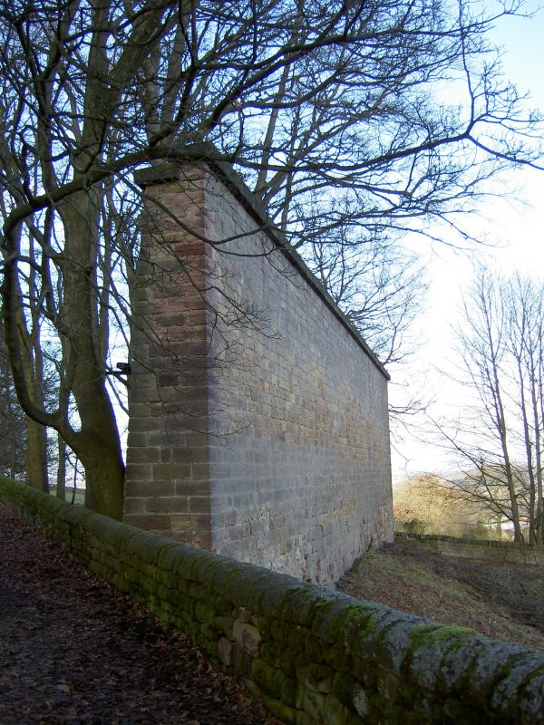
SK 34 NW BELPER NORTH LANE
950- /6/10002 Former Target Wall and Firing
Butts.
II
Former firing range. Circa 1800, the target wall dated 1800. The range is comprised of a tall
tapering target wall, aligned north east-south west. approx. 25 metres long and 5 metres high. The wall is built of coursed squared gritstone, with a heavy flat gritstone coping. To the south east of the wall are a group of 5 regularly- spaced rectangular coursed stone firing butts or platforms, the first being approx 150 metres from the wall, and spaced every 25 metres thereafter. HISTORY: the firing range was built for the local militia, The Belper Volunteer Battalion, raised by Strutt family who established the textile factory communities at Belper and Milford. Lt. Cl. Joseph Strutt was the battalion commander. The range was used during the Napoleonic Wars, and again in 1860, during the Boer War and the First World War. The firing range is important evidence of the part played by local militias in the national defence strategy of the early C19, and is a rare survival of the period.
Listing NGR: SK3415845879
External links are from the relevant listing authority and, where applicable, Wikidata. Wikidata IDs may be related buildings as well as this specific building. If you want to add or update a link, you will need to do so by editing the Wikidata entry.


Other nearby listed buildings
