Approximate Location Map
Large Map »
Latitude: 53.104 / 53°6'14"N
Longitude: -2.0259 / 2°1'33"W
OS Eastings: 398363
OS Northings: 356314
OS Grid: SJ983563
Mapcode National: GBR 24P.JLQ
Mapcode Global: WHBCH.V7GQ
Plus Code: 9C5V4X3F+JJ
Entry Name: Ash Almshouses, Retaining Wall and Railings
Listing Date: 13 April 1951
Last Amended: 14 October 1996
Grade: II
Source: Historic England
Source ID: 1268669
English Heritage Legacy ID: 461593
ID on this website: 101268669
Location: Leek, Staffordshire Moorlands, Staffordshire, ST13
County: Staffordshire
District: Staffordshire Moorlands
Civil Parish: Leek
Built-Up Area: Leek
Traditional County: Staffordshire
Lieutenancy Area (Ceremonial County): Staffordshire
Church of England Parish: Leek St Edward the Confessor
Church of England Diocese: Lichfield
Tagged with: Almshouse
LEEK
SJ9856SW BROAD STREET
611-1/6/19 (South side)
13/04/51 Nos.1-11 (Odd)
Ash Almshouses, retaining wall and
railings
(Formerly Listed as:
BROAD STREET
Ash Almshouses)
GV II
Includes: Nos.2 AND 4 COMPTON.
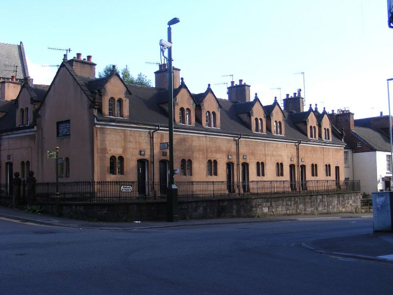
Almshouses. 1676. Restored 1811. Concrete render over stone
with plain-tiled roofs.
EXTERIOR: one-and-a-half storeys, 7-window range, the gabled
dormers each housing paired round-arched windows. Paired
narrow round-arched windows each side of paired doorways with
shallow segmental heads and round-arched panels. Plaques over
each doorway inscribed with name of village from whence the
beneficiary was supposed to come. Return to Compton similarly
detailed, with paired central doors and flanking paired
round-arched windows, with 2 gabled dormers above. Ornate
moulded kneelers to coping of gables, and ball finials on end
gables. Axial stacks.
INTERIOR: not inspected.
SUBSIDIARY FEATURES: the properties are separated from the
road by a roughly coursed and squared stone retaining wall
surmounted by iron spearhead railings and incorporating a
milestone in the Broad Street elevation.
Listing NGR: SJ9836356314
External links are from the relevant listing authority and, where applicable, Wikidata. Wikidata IDs may be related buildings as well as this specific building. If you want to add or update a link, you will need to do so by editing the Wikidata entry.


Other nearby listed buildings
