Approximate Location Map
Large Map »
Latitude: 51.7949 / 51°47'41"N
Longitude: -0.0803 / 0°4'49"W
OS Eastings: 532484
OS Northings: 212434
OS Grid: TL324124
Mapcode National: GBR KBQ.JHL
Mapcode Global: VHGPN.K4DW
Plus Code: 9C3XQWV9+WV
Entry Name: Bailey Walls, South East Range to Hertford Castle (Hertford Castle Demolished)
Listing Date: 10 February 1950
Last Amended: 9 September 1996
Grade: II*
Source: Historic England
Source ID: 1268985
English Heritage Legacy ID: 461233
ID on this website: 101268985
Location: Hertford, East Hertfordshire, SG14
County: Hertfordshire
District: East Hertfordshire
Civil Parish: Hertford
Built-Up Area: Hertford
Traditional County: Hertfordshire
Lieutenancy Area (Ceremonial County): Hertfordshire
Church of England Parish: Hertford St Andrew with St Nicholas
Church of England Diocese: St.Albans
Tagged with: Wall
HERTFORD
TL3212SE HERTFORD CASTLE
817-1/19/311 Bailey walls, south-east range to
10/02/50 Hertford Castle (Hertford Castle
demolished)
(Formerly Listed as:
Hertford Castle: SE range Bailey
Walls, N range Bailey Walls)
GV II*
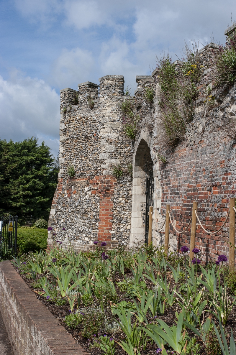
Curtain wall along south-east side of Castle Bailey. Late C12,
c1171-4, with later repairs and alterations. Flint rubble with
clunch quoins, with repairs in Portland stone and red brick,
English bond. At left (SW corner) is ruined polygonal tower,
known as the postern, flint with clunch quoins, with early C19
crenellations with Portland stone caps. To the north is the
truncated spur of the west wall which was originally linked to
the gate house, and was demolished by the Marquess of
Downshire c1791. To the east is a postern gate, with an
unmoulded pointed arch and vault in clunch, C13, restored. The
main run of the wall extends north-eastwards, 1.7-2m thick,
4-5m high max, externally much repaired in brick with early
C19 crenellations. This run of walls terminates in a late C18
gateway constructed on the site of the angle bastion, the
remains of which were demolished, and the curtain wall was
substantially reconstructed to accommodate a broad Tudor
headed skew arch, with twin leaf gates, east with 4 long
raised panels, nail studded stiles and moulded caps.
HISTORICAL NOTE: Hertford Castle reputedly originated as a
Saxon fort built by order of King Alfred against the Danes
encamped at Ware. The castle was built (or reconstructed) by
William I shortly after 1066 as a motte and bailey - the motte
mount, 22 ft high, remains in the north angle of the castle
precinct overlooking the river. In 1171-4, at the behest of
Henry II »171 was spent, probably on the replacement of the
wooden palisade by the flint rubble curtain wall. The castle
was periodically improved and had a double moat, the outer
moat following the line of the north side of Castle Street,
and the east side of Parliament Square and The Wash. An
embankment separated the two moats, broadening into the Outer
Ward to the west of the Gate House. The inner moat ran around
the perimeter of the curtain wall. Long since infilled, the
vestiges of the moats can be seen in the undulating land forms
of the approach to the south postern from Castle Street, and
in the hollow behind the properties in Castle Street and
Parliament Square. The Bailey occupies an area of 2.3 acres,
and the castle precinct 7.75 acres.
Hertford Castle Gate House, curtain walls, motte and bailey
and precinct (qqv) are a Scheduled Ancient Monument.
(Turnor L: History of Hertford: Hertford: 1830-: 16-52,
308-12; Victoria History of the Counties of England:
Hertfordshire: London: 1902-1912: 501-6; Royal Commission on
Historical Monuments (England): An Inventory of the Historical
Monuments of Hertfordshire: London: 1910-: 113; The King's
Works: London: 1963-: 678-71; Hertfordshire Countryside:
Davies HG: 'From Royal Palace to Council Offices': Letchworth:
1946-1971: 34-38; The Buildings of England: Pevsner N:
Hertfordshire: Harmondsworth: 1977-: 187).
Listing NGR: TL3248412433
External links are from the relevant listing authority and, where applicable, Wikidata. Wikidata IDs may be related buildings as well as this specific building. If you want to add or update a link, you will need to do so by editing the Wikidata entry.


Other nearby listed buildings
