Approximate Location Map
Large Map »
Latitude: 54.1958 / 54°11'44"N
Longitude: -2.9029 / 2°54'10"W
OS Eastings: 341192
OS Northings: 478159
OS Grid: SD411781
Mapcode National: GBR 8M5X.BP
Mapcode Global: WH83D.CSXS
Plus Code: 9C6V53WW+8V
Entry Name: Grange over Sands Railway Station
Listing Date: 2 May 1975
Last Amended: 12 July 1996
Grade: II
Source: Historic England
Source ID: 1269659
English Heritage Legacy ID: 460552
Also known as: Grange-over-Sands
ID on this website: 101269659
Location: Grange-over-Sands, Westmorland and Furness, Cumbria, LA11
County: Cumbria
District: South Lakeland
Civil Parish: Grange-over-Sands
Traditional County: Lancashire
Lieutenancy Area (Ceremonial County): Cumbria
Church of England Parish: Grange-over-Sands St Paul
Church of England Diocese: Carlisle
Tagged with: Railway station
SD47NW
705-1/2/42
02/05/75
GRANGE-OVER-SANDS
STATION SQUARE
(South side)
Grange-Over-Sands Railway Station
(Formerly Listed as:
LINDALE ROAD
Grange Over Sands Railway Station)
GV
II
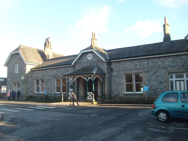
Railway station. Rebuilt c1877. By EG Paley for the Furness
Railway. Snecked limestone rubble with rock-faced sandstone
dressings and Westmorland slate roof. Main range (N),
symmetrical 1:2:1:2:1, the outer bays of 2 storeys, projecting
under half-hipped roofs; the rest single-storey. Windows
mainly paired sash windows. Central entrance under half-hipped
gable, with open timber porch. Ridge stacks. On the south side
a timber canted bay window looks out onto the platform, which
is covered by a 5-bay glass canopy on cast-iron columns. The
southern platform is covered by a similar canopy, with a
screen wall containing 5 windows of 3 round-headed lights.
Gabled end pavilions have carved bargeboards and windows of 2
round-headed lights separated by shafts.
Listing NGR: SD4119278159
External links are from the relevant listing authority and, where applicable, Wikidata. Wikidata IDs may be related buildings as well as this specific building. If you want to add or update a link, you will need to do so by editing the Wikidata entry.


Other nearby listed buildings
