Approximate Location Map
Large Map »
Latitude: 54.6673 / 54°40'2"N
Longitude: -1.6818 / 1°40'54"W
OS Eastings: 420619
OS Northings: 530291
OS Grid: NZ206302
Mapcode National: GBR JGPG.PP
Mapcode Global: WHC52.4YDC
Plus Code: 9C6WM889+W7
Entry Name: Newton Cap Railway Viaduct over River Wear
Listing Date: 20 September 1972
Last Amended: 1 June 2022
Grade: II
Source: Historic England
Source ID: 1269762
English Heritage Legacy ID: 460431
ID on this website: 101269762
Location: Town Head, County Durham, DL14
County: County Durham
Civil Parish: Bishop Auckland
Built-Up Area: Bishop Auckland
Traditional County: Durham
Lieutenancy Area (Ceremonial County): County Durham
Church of England Parish: Bishop Auckland
Church of England Diocese: Durham
Tagged with: Road bridge Architectural structure Railway viaduct
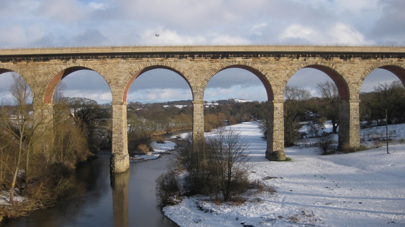
Railway Viaduct, 1854-1857 for the North Eastern Railway (NER) Bishop Auckland Branch line.
Railway Viaduct, 1854-1857 for the North Eastern Railway (NER) Bishop Auckland Branch line.
MATERIALS: rock-faced sandstone with ashlar dressings and brick-lined soffits.
PLAN: rectangular, oriented roughly north to south.
DESCRIPTION: the viaduct is about 828ft (252.374m) long, and comprises 11 semi-circular arches, each of 60ft (18.288m) span, supported on tall masonry piers and abutments which taper upwards to an ashlar impost band. Counting from the south, the seventh and eighth arches span the River Wear (about 100ft below), while the ninth spans a local access road. The basal courses of piers five to eight stand on the floodplain, and are extended forward and back to form boat-shaped cutwaters that rise to domed, ashlar tops; all other piers rise straight from the valley sides. The arches have single arch rings formed of large stone voussoirs; the soffit of each arch is executed in red brick. All stonework is rock-faced apart from the undersides of the arch rings where it is smooth to match the brickwork, and the impost bands on the piers and a second band at the level of the cutwater caps on the floodplain piers, which are also ashlar. Original parapets were removed or obscured by the insertion of the current road deck, but the ashlar string course with roll moulding from which they rose, is visible. The modern road deck is a concrete slab cantilevered out over the viaduct elevations to allow for the inclusion of footpaths either side of the carriageway; the present parapets are crash-proof metal fences affixed to the edges of the road deck.
Newton Cap Viaduct, railway Engineer’s Line Reference (ELR) bridge no DBA/7, was built by the North Eastern Railway (NER) between 1854 and 1857 to take the Durham and Bishop Auckland Branch line across the River Wear and into the town of Bishop Auckland. It is one of three very similar stone viaducts on the line, the others being at Durham (National Heritage List for England (NHLE): entry: 1322851) and Belmont (NHLE entry: 1120726). The line closed in 1968, and in 1972 it was converted into a recreational footpath. In 1993 the viaduct was re-purposed and re-decked to carry road traffic as part of the Toronto Bypass scheme designed to relieve traffic through the small mining village of that name that stands on the north bank of the Wear. This is considered a pioneering scheme, and the first example in England of a former railway bridge specifically adapted and widened for road traffic. The viaduct's original low parapets with flat copings, interrupted at intervals by pilasters with low pyramidal caps, were either removed or obscured by the insertion of the current concrete road deck.
The Durham to Bishop Auckland branch line was built by the NER to designs probably by their Chief Engineer, Thomas Elliott Harrison. The line had been proposed in 1846 and groundworks were underway in 1848, but work was abandoned and did not re-start until 1853 by which time a different contractor, Richard Cail, had been appointed. The resident engineer for the NER was Robert Hodgson. Sandstone was sourced from quarries at Rudchester, Penshaw, Gateshead and Leam and the foundations for the river piers required the construction of coffer dams 20ft (6.1m) deep.
Newton Cap Viaduct (DBA/7), erected between 1854 and 1857, is listed at Grade II for the following principal reasons:
Architectural interest:
* in scale, aesthetic quality and design, it is a striking and impressive mid-C19 railway viaduct;
* it is well-executed in local rusticated stone and ashlar, which displays good quality craftsmanship and detailing;
* a well-preserved railway structure, whose interest is undiminished by the addition of a later-C20 concrete road deck.
Historic interest:
* a good illustration of the third phase of railway development in England, from the 1850s to the 1870s, which saw the consolidation of the network;
* it is the first example in England of the re-purposing of a railway bridge to a road bridge.
Group value:
* it benefits from a historic and functional group value with other railway structures, including two other contemporary railway viaducts on the same line at Brandon and Durham.
External links are from the relevant listing authority and, where applicable, Wikidata. Wikidata IDs may be related buildings as well as this specific building. If you want to add or update a link, you will need to do so by editing the Wikidata entry.


Other nearby listed buildings
