Approximate Location Map
Large Map »
Latitude: 51.282 / 51°16'55"N
Longitude: 1.0709 / 1°4'15"E
OS Eastings: 614255
OS Northings: 158126
OS Grid: TR142581
Mapcode National: GBR TY2.FLK
Mapcode Global: VHLGM.J10L
Plus Code: 9F3373JC+Q9
Entry Name: 20 and 21, Orchard Street
Listing Date: 7 September 1973
Grade: II
Source: Historic England
Source ID: 1270254
English Heritage Legacy ID: 459871
ID on this website: 101270254
Location: St Dunstan's, Canterbury, Kent, CT2
County: Kent
District: Canterbury
Electoral Ward/Division: Westgate
Parish: Non Civil Parish
Built-Up Area: Canterbury
Traditional County: Kent
Lieutenancy Area (Ceremonial County): Kent
Tagged with: Building
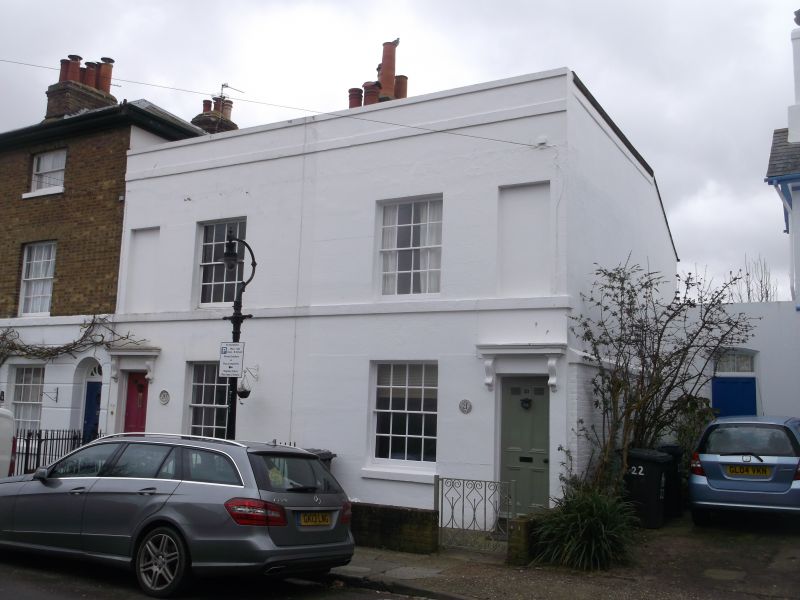
1.
944 ORCHARD STREET
(South East Side)
Nos 20 and 21
TR 1458 SW 1/634
II GV
2.
Circa 1840. 2 storeys stuccoed. Parapet and stringcourse. 1 sash each with
glazing bars intact and 1 blank. Doorcases have vestigial hoods and console
brackets. 4 panelled doors. Plinth.
Nos 1B to 25 (consec) form a group.
Listing NGR: TR1425658128
External links are from the relevant listing authority and, where applicable, Wikidata. Wikidata IDs may be related buildings as well as this specific building. If you want to add or update a link, you will need to do so by editing the Wikidata entry.


Other nearby listed buildings
