Approximate Location Map
Large Map »
Latitude: 52.95 / 52°57'0"N
Longitude: -1.1575 / 1°9'26"W
OS Eastings: 456704
OS Northings: 339512
OS Grid: SK567395
Mapcode National: GBR LMQ.HN
Mapcode Global: WHDGZ.632S
Plus Code: 9C4WXR2V+22
Entry Name: Fothergill House and Attached Boundary Wall
Listing Date: 12 July 1972
Last Amended: 30 November 1995
Grade: II
Source: Historic England
Source ID: 1270678
English Heritage Legacy ID: 457432
ID on this website: 101270678
Location: Standard Hill, Nottingham, Nottinghamshire, NG7
County: City of Nottingham
Electoral Ward/Division: Radford and Park
Parish: Non Civil Parish
Built-Up Area: Nottingham
Traditional County: Nottinghamshire
Lieutenancy Area (Ceremonial County): Nottinghamshire
Church of England Parish: Nottingham St Peter with St James
Church of England Diocese: Southwell and Nottingham
Tagged with: Building
This List entry was subject to a Minor Amendment on 31/10/2017
SK 5639 NE,
646-1/19/316
NOTTINGHAM,
LENTON ROAD (south-east side),
No. 7, Fothergill House and attached boundary wall
(Formerly Listed as: LENTON ROAD No.7 Parkside)
12/07/72
GV
II
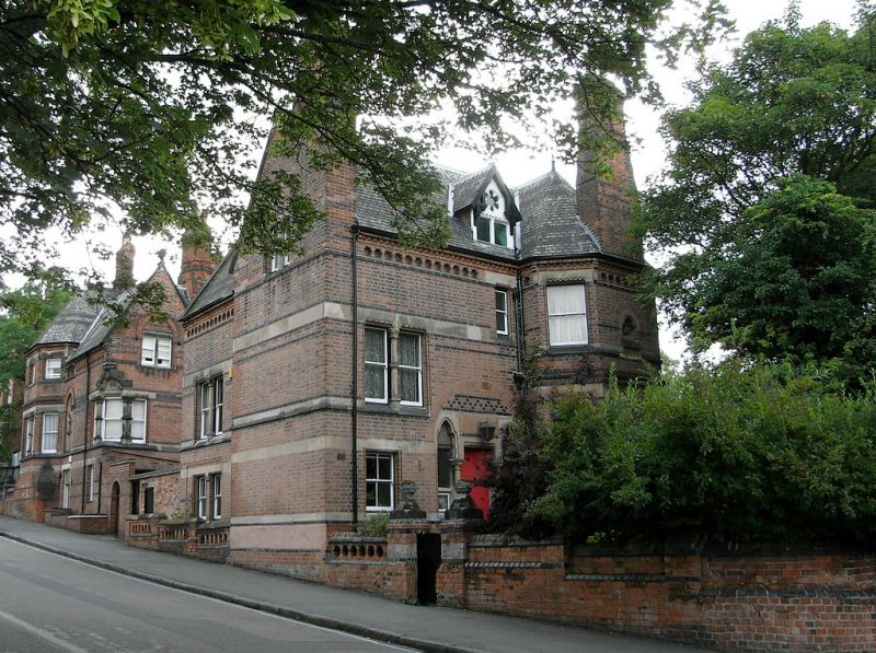
House and attached boundary wall. Dated 1873. By Watson
Fothergill of Nottingham for the Misses Woods. Red brick, with
blue brick and ashlar dressings and banded slate roofs of
several forms. Gothic Revival style.
Plinth, polychrome ashlar bands, corbel table, moulded eaves.
Windows are mainly original plain sashes with ashlar lintels.
Two and three storeys plus attics; 2-window range.
Main front, to west, has a central panelled door with shafts,
flanked by taller trefoil-headed sidelights with leaded
glazing. To left, a sash, and above it, a paired sash. Above
again, to right, a smaller sash, and over it, a gabled dormer
with a 2-light casement and traceried head. At the left
corner, a coped brick stack. To right, a massive canted bay
window, three storeys, with pyramidal roof and finial, and central
shouldered coped stack. Single windows each side on each
floor, the upper windows smaller. On the second floor, a
central pointed arched recess with date stone.
Outside, attached boundary wall, brick, with moulded brick and
ashlar stepped coping. Lenton Road stretch, approx. 10m long,
has a gateway with square brick piers, flanked by short
lengths with plain balustrades. Acute angled corner to return
along Ogle Drive, approx. 45m long.
Listing NGR: SK5670439512
External links are from the relevant listing authority and, where applicable, Wikidata. Wikidata IDs may be related buildings as well as this specific building. If you want to add or update a link, you will need to do so by editing the Wikidata entry.


Other nearby listed buildings
