Approximate Location Map
Large Map »
Latitude: 51.8598 / 51°51'35"N
Longitude: -2.2543 / 2°15'15"W
OS Eastings: 382585
OS Northings: 217944
OS Grid: SO825179
Mapcode National: GBR 1L5.6XB
Mapcode Global: VH94B.WJ34
Plus Code: 9C3VVP5W+W7
Entry Name: Downings Malthouse Extension
Listing Date: 12 March 1973
Last Amended: 15 December 1998
Grade: II
Source: Historic England
Source ID: 1271708
English Heritage Legacy ID: 472346
ID on this website: 101271708
Location: High Orchard, Gloucester, Gloucestershire, GL2
County: Gloucestershire
District: Gloucester
Electoral Ward/Division: Westgate
Parish: Non Civil Parish
Built-Up Area: Gloucester
Traditional County: Gloucestershire
Lieutenancy Area (Ceremonial County): Gloucestershire
Church of England Parish: Hempsted with Gloucester, Saint Mary de Lode and Saint Mary de Crypt
Church of England Diocese: Gloucester
Tagged with: Architectural structure
GLOUCESTER
SO8217 MERCHANTS' ROAD
844-1/15/199 (West side)
12/03/73 Downing's Malthouse Extension
(Formerly Listed as:
BAKER'S QUAY
Gloucester & Sharpness Canal
Malthouse (G & WE Downing))
GV II
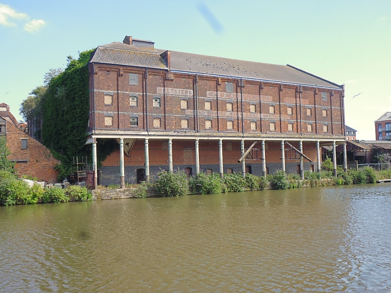
Malthouse. A large extension to Downing's Malthouse (qv) on
east side of Merchants' Road, with a gallery bridge linking
both buildings at high level above the road. 1899-1901. By
Walter B Wood of Gloucester, for G and WE Downing, maltsters;
various C20 alterations.
MATERIALS: red brick with white brick and stone details,
cast-iron colonnade, internally iron columns, slate roofs
behind stone coped gables and parapets.
PLAN: a pair of similar, parallel, end-gabled blocks on
north-south axis, the blocks originally separated by narrow
gap later infilled with structure faced at south end with
corrugated iron, and the west side of the west block
projecting over Baker's Quay, its west wall supported on a
colonnade above the revetment wall facing the Gloucester and
Sharpness Canal; at the north end a large cross range which
once contained kilns.
EXTERIOR: six storeys, cellar and loft; in parallel blocks
each gable-end wall of five bays and the side walls of ten
bays, with tall ground floor storey capped by a raised ashlar
band; bays on the upper floors framed by strip pilasters and
quoin strips; a horizontal strip across the bases of each
gable and deep, raking strips, stepped on the undersides, on
the faces of the gable copings; on each side a deep, strip
cornice, with raised panels above each pilaster strip, applied
to the parapet; at each-floor level a narrow band of
contrasting bricks.
On the side of the east block facing Merchants' Road in second
bay from left a doorway to offices on the ground floor at
south end, the doorway within a recess with cambered-arched
head, at the top of the recess a stone panel with carved
inscription "G & W.E DOWNING" above "MALTSTERS"; on stone
lintel over doorway in the centre "OFFICES" flanked by small
panels inscribed "BUILT" and "1901"; in bays to each side of
doorway and in north gable-end wall large windows to offices
with keystones in segmental-arched heads, otherwise in both
blocks, on ground floor at high level, and in most bays to
each upper floor small windows with cambered-arched heads, now
infilled in brick.
On the west side of the west block the upper floors supported
above Baker's Quay by a colonnade of 13 cast-iron columns with
moulded caps and bases set on the revetment.
The block at the north end is lower, of three storeys, and
three bays to east and fourteen bays on north side, and with
similar pilaster strips, quoin strips, parapets, contrasting
storey bands and window openings in each bay on the east side,
but on the north side mostly in alternate bays.
INTERIOR: some original staircases. Kilns shown in original
drawings.
(Gloucester Records Office: D2460 Drawings 1-C).
Listing NGR: SO8258517943
External links are from the relevant listing authority and, where applicable, Wikidata. Wikidata IDs may be related buildings as well as this specific building. If you want to add or update a link, you will need to do so by editing the Wikidata entry.


Other nearby listed buildings
