Approximate Location Map
Large Map »
Latitude: 52.3997 / 52°23'58"N
Longitude: 0.2649 / 0°15'53"E
OS Eastings: 554189
OS Northings: 280379
OS Grid: TL541803
Mapcode National: GBR M6H.FSY
Mapcode Global: VHHJ6.JYX8
Plus Code: 9F4297X7+VX
Entry Name: 3 High Street Passage
Listing Date: 18 May 1998
Last Amended: 18 November 2016
Grade: II
Source: Historic England
Source ID: 1271807
English Heritage Legacy ID: 468660
ID on this website: 101271807
Location: Ely, East Cambridgeshire, CB7
County: Cambridgeshire
District: East Cambridgeshire
Civil Parish: Ely
Built-Up Area: Ely
Traditional County: Cambridgeshire
Lieutenancy Area (Ceremonial County): Cambridgeshire
Church of England Parish: Ely
Church of England Diocese: Ely
Tagged with: Building
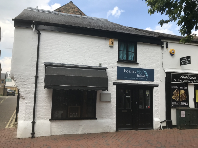
A former shop and open hall house of late-C15/early-C16 date, with the hall ceiled and a stack inserted in the late C16/early C17. It was further remodelled in the C17/early C18, mid-C19 and late C20. Now (2016) an holistic therapy practice.
A former shop and open hall house of late-C15/early-C16 date, with the hall ceiled and a stack inserted in the late-C16/early-C17. It was further remodelled in the C17/early-C18, mid-C19 and late C20. Now (2016) an holistic therapy practice.
MATERIALS: it has a brick encased timber-frame, with some stone, a brick plinth and a mono-pitched roof covered with late-C20 slate.
PLAN: it is of two storeys with a rectangular plan.
EXTERIOR: to the ground floor of the east side of the building there is a C19, tripartite, plate-glass shop window at the left-hand side and a C20 double doorway with two half-glazed entrance doors at the right-hand side. On the first floor, directly above the doorway, there is a two-light casement with square-paned glazing. To the right-hand side of the south front there is an identical C19 shop window. It is flanked on its left-hand side by two, small, single-light casements of which the left-hand casement is set within the timber surround of a blocked late-C15/early-C16 doorway. The first floor is jettied and has a curved jetty bracket rising from a concealed, central wall post to an exposed joist. A small section of corresponding bressumer is exposed and is ornamented with moulded horizontal bands. The upper section of the south-east corner post is also visible and has a curved upper section which projects to support a dragon beam. The south-east corner beneath the jetty has now been underbuilt in brick and has a large corbelled bracket supporting the upper storey. To the first floor there is a C19 two-light casement with square-paned glazing. It is flanked on each side by C20, unframed, four-light mullioned windows of which the mullions are formed by the main wall studs. To the attic is a fixed casement with square-paned glazing.
INTERIOR: running east to west through the ground floor is a large cross beam supported on a late-C20 centre post. It is unchamfered with a series of residual mortises on its underside which indicate the position of the former partition which divided the south-side shop from the north-side hall. A small section of beam at the extreme west end, which now lies within a late-C20 laundry room, appears to be a later insertion into a former doorway between the hall and shop; the doorway itself has now been infilled with brick. A chamfered spine beam with scroll stops runs north to south from the central post and divides the original shop unit into two equal bays. A dragon beam projects from the central post to the south-east corner and is similarly detailed. The original joists are concealed by a later boarded ceiling, but their positions are indicated by pegs in the dragon beam and spine beam. The south-east corner post has residual mortises towards the top of its south and west faces. An adjacent stud in the south wall has corresponding mortises. The underside of the jetty plate between these two features has a series of smaller mortises which indicate the position of the original four-light shop window which was enlarged in the C19. To the right-hand side of the window are surviving sections of close studding while further residual mortises on the underside of the southern jetty indicate the positions where studding has been removed. Running north to south from the central post to the north wall is a late-C16/early-C17 chamfered spine beam with a double-ogee moulding and scroll stops. Also inserted at the same time, against the west elevation, in the north corner of the former hall, is a brick fireplace with a timber bressummer. To the left-hand side of the fireplace, again annexed in the late-C20 laundry room, is a blocked, timber-framed doorway to the former external west wall. A late-C20 staircase runs parallel with the north wall.
On the first floor the two bays are defined by jowled posts supporting three tie beams, the only components to survive from the original trusses. The south wall is close-studded, largely concealed by late-C20 plasterboard, but visible where infill was removed in the late C20 to create two windows. Centrally placed is an original window opening. A large rebate on the lower edge of the tie-beam extends outwards on either side of the window and would have accommodated a pair of shutters. Part of the eastern brace survives and is visible internally, but evidence for the western brace is either concealed or lost. Although the east and west elevations have been altered, both retain their wall plates with evidence for peg holes also indicating that these two sides were close studded. While the original form of the north elevation has been largely concealed or altered, it still retains its north-west corner post. The tie beam at this end is cambered and has no evidence of pegging for close studding, as in the other elevations, but there is a centrally-placed stud which is double pegged to the tie beam. West of this is a further pair of pegs, although any corresponding timber has been removed or concealed. Any indication of further studs or other features in this tie beam are concealed by a build-up of plasterwork, particularly against the eastern end of the beam.
The attic is covered by a C19 mono-pitch roof whose apex is supported by salvaged timbers which includes a substantial longitudinal timber with a series of residual mortises, possibly a reused wall plate. The ridge piece is C19, and the common rafters and joists are concealed by timber boarding.
The present city of Ely rises 20m above the surrounding fen on an island of Kimmeridge clay. Although well connected by river and waterways, until the C17 only causeways connected the island to the mainland, and in the early years of Christianity its isolation made it an ideal refuge for those seeking a secluded monastic life. The first successful attempt to establish a religious settlement here was made by Etheldreda in c 673, re-endowed by King Edgar 100 years after its destruction by the Danes in 870. Despite threats of further invasion in the C11, and later political turmoil, this monastery survived until its dissolution in 1539. The presence of a monastic community occupying substantial buildings required the support of a lay community, and as that grew, so did the needs of the lay-people for accommodation and services. A detailed survey of 1416 recorded 457 buildings and described an established street pattern; by 1563 the number of households had grown to 800. Despite this growth in population, John Speed’s map of Ely, published in 1611/12, is very similar in both layout and extent to that of the first edition Ordnance Survey (OS) Map of 1885, where the only significant expansion is towards the railway (1845): however, in Speed’s map, houses lining the streets enclose spaces of apparently horticultural and even agricultural production, and while these are still present on the 1885 map they have been pushed to the margins of the city. These maps graphically illustrate the continuing importance of agriculture and its related industries in the early C17 and beyond, and also show that the later growth in population took place mainly within the confines of the early city street plan. Before the later C19, the only significant rival to agriculture was the pottery industry, in production from the C12 to 1860.
Following the dissolution of the monastery, Ely remained the centre of the diocese, but the loss of the community, and of pilgrims to the shrine of St Etheldreda, would have had a considerable impact on the city’s economy. The consequent decline in management of the fen and its waterways led to an increase in flooding, and attempts at drainage in the C17 and C18 seem to have had limited effect, creating constraints on the ability of the city to thrive. Successive literary travellers commented on the poor drainage, including Celia Fiennes in the mid-C17, who described the city as a “perfect quagmire”, and Daniel Defoe in the early C18, who noted both the city’s market gardens and its overflowing wells. By the mid-C19 the city was in a state of recovery and regeneration: several possible contributory factors include successful drainage, enclosure (1848) and the arrival of the railway with the opening of the Cambridge to Ely line in 1845. This was followed slightly later by other lines, making the city a transport hub. Despite this, the physical expansion of Ely beyond its medieval core was slow through the mid-C20, accelerating through the late C20 and into the C21, as Ely developed as a dormitory town for Cambridge.
No.3 High Street Passage, now (2016) a holistic therapy practice, forms part of a row of buildings that stand on a plot to the rear of the buildings occupying the north side of Market Street. It stands at the eastern end of this row and fronts onto High Street Passage, a narrow pedestrian alleyway running from High Street in the south to Market Street in the north. Immediately to its south is High Street Back and immediately to its north is Butcher's Row. It is believed that the whole area between High Street and Market Street was a large market place in the medieval period with the residual name of Butcher's Row possibly indicating an association with butchery and meat preparation. No 3 High Street Passage provides evidence for permanent buildings being erected on the market place in the late medieval period. It was built in the late-C15/early-C16 as a two-bay, jettied, timber-framed shop with an open hall to the rear (north).
In the late C16/early C17, the hall was ceiled, a stack inserted and a door opening created in the west elevation, probably to provide a separate entrance to the former open hall area, thereby allowing greater flexibility for the occupancy of the building.
A substantial remodelling of the eastern elevation took place in the C17 or early C18, with the jetty being underbuilt in brick. As the south front remained unaltered, this possibly suggests that the east face to High Street Passage was more important commercially.
Further alterations took place in the mid-C19, probably in association with the construction of the Baptist Chapel which was built adjoining the west side of the building in 1853. Whether the chapel replaced earlier building(s) is unknown, but the insertion of most of the brickwork into this elevation, particularly the ground floor, took place at this time, along with the addition of a mono-pitch roof. Although salvaged timber has been used to support the roof, it is unknown as to whether it came from this building or from the timber-framed buildings which were demolished to make way for the chapel.
In the late C20 the building was re-configured internally for commercial use, including subdivisions at ground- and first-floor level along with the insertion of a new staircase against the north wall. Related to this is the insertion of paired doorway in the east elevation. Although both are open to the ground-floor shop, it was originally intended to provide for separate access to the lower and upper floors. Additional window openings were also inserted in the first-floor of the south-face with the removal of the infill between the close studding.
No 3 High Street Passage, a former shop and open hall house of late-C15/early-C16 date, with later alterations, is listed at Grade II for the following principal reasons:
* Architectural interest: for the surviving core of a late-C15/early-C16 shop and open hall house, with evidence for its evolution also adding to its interest. Its is constructed from good quality local materials and displays evidence of the local building tradition in its carpentry;
* Degree of survival: it retains a significant proportion of its late-medieval fabric, including studwork, a jettied bressumer beam, a dragon beam and window and door openings. Its original urban vernacular form of a street frontage shop with an open hall to the rear is still legible;
* Historic interest: it lies within the area of settlement described on John Speed’s map of 1610/1611, a street pattern established by the early C15, and contributes to the understanding of the historical development of the townscape;
* Group value: its has strong functional relationship with the listed buildings on the High Street.
External links are from the relevant listing authority and, where applicable, Wikidata. Wikidata IDs may be related buildings as well as this specific building. If you want to add or update a link, you will need to do so by editing the Wikidata entry.


Other nearby listed buildings
