Approximate Location Map
Large Map »
Latitude: 51.3643 / 51°21'51"N
Longitude: -2.0351 / 2°2'6"W
OS Eastings: 397652
OS Northings: 162800
OS Grid: ST976628
Mapcode National: GBR 2TS.G8W
Mapcode Global: VHB47.NZZ1
Plus Code: 9C3V9X77+PX
Entry Name: Barn to West of Myrtle Farmhouse
Listing Date: 17 September 1976
Last Amended: 3 April 1987
Grade: II
Source: Historic England
Source ID: 1272905
English Heritage Legacy ID: 447205
ID on this website: 101272905
Location: Rowde, Wiltshire, SN10
County: Wiltshire
Civil Parish: Rowde
Built-Up Area: Rowde
Traditional County: Wiltshire
Lieutenancy Area (Ceremonial County): Wiltshire
Tagged with: Barn
ROWDE BUNNIES LANE
ST 9762
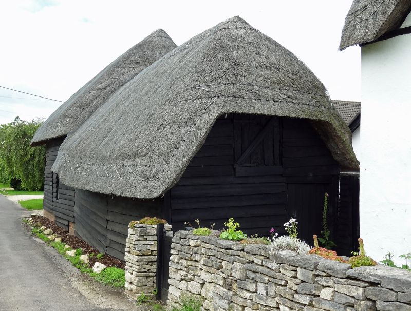
11/225 Barns to west of Myrtle
Farmhouse
(formerly listed with house)
17.9.76
II
Pair of small barns, late C17 or c18, timber-framed with tarred
weatherboarding and thatched half-hipped roofs. Taller west barn
has south side double doors, slightly lower attached barn to east
has loading door in east gable.
Listing NGR: ST9765262800
External links are from the relevant listing authority and, where applicable, Wikidata. Wikidata IDs may be related buildings as well as this specific building. If you want to add or update a link, you will need to do so by editing the Wikidata entry.


Other nearby listed buildings
