Approximate Location Map
Large Map »
Latitude: 51.0661 / 51°3'58"N
Longitude: -1.7898 / 1°47'23"W
OS Eastings: 414822
OS Northings: 129663
OS Grid: SU148296
Mapcode National: GBR 51F.498
Mapcode Global: FRA 7649.GK6
Plus Code: 9C3W3686+C3
Entry Name: 60-66, St Ann Street
Listing Date: 28 February 1952
Last Amended: 26 January 1977
Grade: II*
Source: Historic England
Source ID: 1273236
English Heritage Legacy ID: 445784
ID on this website: 101273236
Location: The Friary, Wiltshire, SP1
County: Wiltshire
Civil Parish: Salisbury
Built-Up Area: Salisbury
Traditional County: Wiltshire
Lieutenancy Area (Ceremonial County): Wiltshire
Church of England Parish: Salisbury St Martin
Church of England Diocese: Salisbury
Tagged with: Building
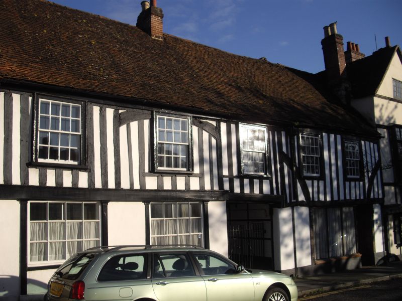
ST ANNE'S STREET
1.
1594 (South Side)
Nos 60 to 66 (even)
(Formerly listed as
Nos 60 & 66)
SU 1429 NE 4/172 28.2.52.
II* GV
2.
Circa 1500 with C18 alterations. 2 storey timber framed with plaster infilling.
Gable end old tile roof. Panelled wings, either side of passage, to rear.
Front has 5 C18 flush architrave framed sashes, glazing bars intact. On ground
floor No 60 has 3 light shop window and door, possibly reset carved wood strips
flanking. To left No 66 C19 double shop front. Central passage entrance giving
access to wings to rear, which are largely of painted brick with C18/C19 flush
architrave framed sashes. However the south ends of both wings are timber framed,
that of No 66 with jettied weatherboarded 1st floor.
Interiors: No 60 has chamfered beams, 2 exposed roof trusses, collars, principals,
curved struts between collars, windbrace. No 66 has exposed tie beam in east
end wall, remains of partition truss with cambered tie beam, curved brace.
South end, tie beam, curved braces to wall posts, raised centre collar, linking
curved struts, butt purlins, curved windbraces.
Nos 44 to 74 (even) and Nos 78 to 82 (even) form a group.
Listing NGR: SU1482229663
External links are from the relevant listing authority and, where applicable, Wikidata. Wikidata IDs may be related buildings as well as this specific building. If you want to add or update a link, you will need to do so by editing the Wikidata entry.


Other nearby listed buildings
