Approximate Location Map
Large Map »
Latitude: 53.656 / 53°39'21"N
Longitude: -1.811 / 1°48'39"W
OS Eastings: 412590
OS Northings: 417744
OS Grid: SE125177
Mapcode National: GBR HVS5.Q4
Mapcode Global: WHCB1.4CXK
Plus Code: 9C5WM54Q+CJ
Entry Name: Gatepiers to Number 12
Listing Date: 29 September 1978
Grade: II
Source: Historic England
Source ID: 1273674
English Heritage Legacy ID: 417438
ID on this website: 101273674
Location: Edgerton, Kirklees, West Yorkshire, HD3
County: Kirklees
Electoral Ward/Division: Greenhead
Parish: Non Civil Parish
Built-Up Area: Huddersfield
Traditional County: Yorkshire
Lieutenancy Area (Ceremonial County): West Yorkshire
Church of England Parish: Lindley St Stephen
Church of England Diocese: Leeds
Tagged with: Gatepost
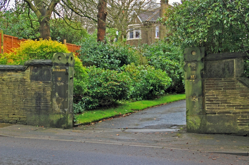
THORNHILL ROAD
1.
5113
(West Side)
Edgerton
Gatepiers to No 12
SE 1217 27/1269
II
2.
Mid C19. Ashlar. Chamfered. Geometrically shaped top.
Listing NGR: SE1259017744
External links are from the relevant listing authority and, where applicable, Wikidata. Wikidata IDs may be related buildings as well as this specific building. If you want to add or update a link, you will need to do so by editing the Wikidata entry.


Other nearby listed buildings
