Approximate Location Map
Large Map »
Latitude: 51.3942 / 51°23'39"N
Longitude: 0.244 / 0°14'38"E
OS Eastings: 556216
OS Northings: 168521
OS Grid: TQ562685
Mapcode National: GBR WF.S79
Mapcode Global: VHHP7.57V0
Plus Code: 9F3296VV+MJ
Entry Name: The Cottage
Listing Date: 22 October 1982
Grade: II
Source: Historic England
Source ID: 1273920
English Heritage Legacy ID: 416425
ID on this website: 101273920
Location: Horton Kirby, Sevenoaks, Kent, DA4
County: Kent
District: Sevenoaks
Civil Parish: Horton Kirby and South Darenth
Built-Up Area: Horton Kirby
Traditional County: Kent
Lieutenancy Area (Ceremonial County): Kent
Church of England Parish: Horton Kirby St Mary
Church of England Diocese: Rochester
Tagged with: Cottage
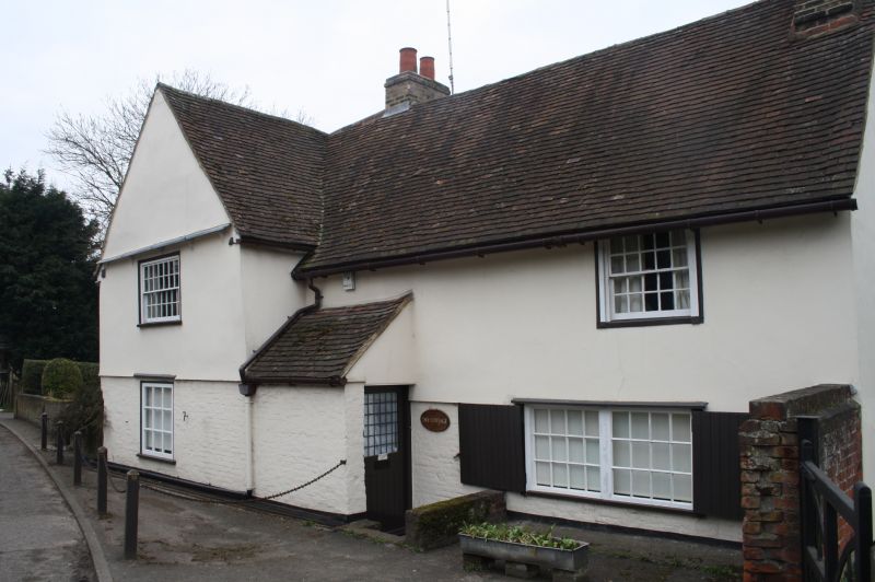
HORTON KIRBY HORTON ROAD
1.
5280
(west side)
The Cottage
TQ 56 NE 3/188
II GV
2.
C17 or earlier timber-framed building refaced in C18. L-shaped. Two storeys.
Faced with plaster on the first floor and with brick, now painted, on the ground
floor. Tiled roof. Gable end facing east. Sashes with glazing bars intact.
Small later addition to the west.
Listing NGR: TQ5621668521
External links are from the relevant listing authority and, where applicable, Wikidata. Wikidata IDs may be related buildings as well as this specific building. If you want to add or update a link, you will need to do so by editing the Wikidata entry.


Other nearby listed buildings
