Approximate Location Map
Large Map »
Latitude: 53.8014 / 53°48'5"N
Longitude: -2.3144 / 2°18'51"W
OS Eastings: 379388
OS Northings: 433949
OS Grid: SD793339
Mapcode National: GBR DS8H.Q1
Mapcode Global: WH96R.FQ43
Plus Code: 9C5VRM2P+H6
Entry Name: Prestige Bedding Centre to South East and North East of Courtyard Facing Mill Street
Listing Date: 19 July 1984
Grade: II
Source: Historic England
Source ID: 1274123
English Heritage Legacy ID: 416068
Also known as: National School
ID on this website: 101274123
Location: Padiham, Burnley, Lancashire, BB12
County: Lancashire
District: Burnley
Civil Parish: Padiham
Built-Up Area: Burnley
Traditional County: Lancashire
Lieutenancy Area (Ceremonial County): Lancashire
Church of England Parish: Padiham with Hapton and Padiham Green
Church of England Diocese: Blackburn
Tagged with: Building Warehouse School building Destroyed building or structure
SD 73 SE PADIHAM MILL STREET
3/43 Prestige Bedding
Centre to SE and NE of
courtyard facing Mill Street
19.7.1984
- II
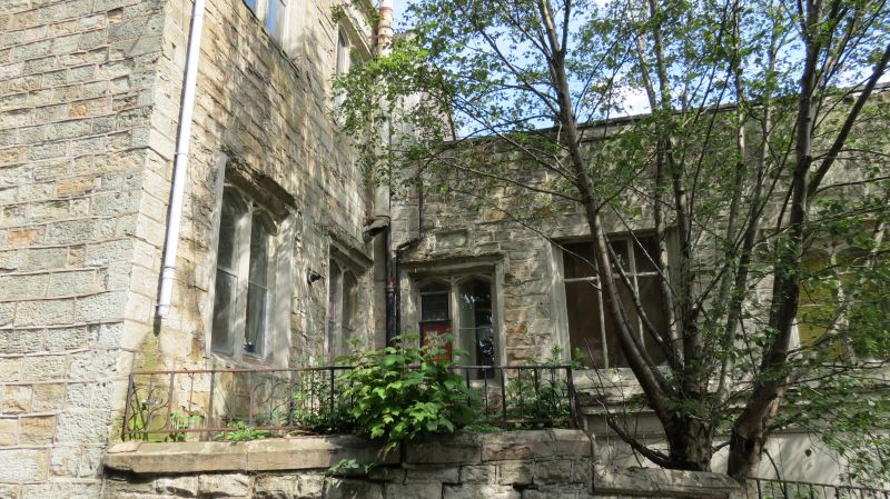
Former National School, now partly used as storage for the Prestige Bedding
Centre. 1830 (6-bay ground floor of wing to right of courtyard with gable
to street) and 1854 (upper floor of this wing and 2-storey wing behind
courtyard) with later alterations and extensions. Dressed sandstone. Stone
slate roofs with gable copings. C17 vernacular style. Earlier wing has one
original chamfered mullioned window with 2 arched lights in centre between 2
openings of c1950. This pattern of window is repeated in all 3 windows on
both storeys of the later wing, while the single light window to the right
of the first floor of that wing is similar. Below this window is a gabled
porch with a 4-centred arched doorway which in 1830 stood towards the middle
of one of the long sides of the school building and was was re-located here
in 1854. A similar doorway (without a porch) to the left was
originally the entrance to the headmaster's study. The building
housed the National School between 1830 and 1902. Wings of 1862 and
1906, which front Burnley Road, are not of special interest.
Listing NGR: SD7938833949
This text is from the original listing, and may not necessarily reflect the current setting of the building.
External links are from the relevant listing authority and, where applicable, Wikidata. Wikidata IDs may be related buildings as well as this specific building. If you want to add or update a link, you will need to do so by editing the Wikidata entry.


Other nearby listed buildings
