Approximate Location Map
Large Map »
Latitude: 51.0544 / 51°3'15"N
Longitude: 0.387 / 0°23'13"E
OS Eastings: 567391
OS Northings: 131045
OS Grid: TQ673310
Mapcode National: GBR NS7.W44
Mapcode Global: FRA C6PB.JKV
Plus Code: 9F32393P+PR
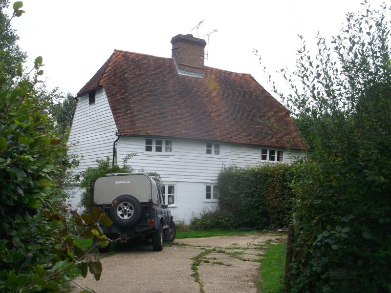
Entry Name: Lower Tolhurst
Listing Date: 1 October 1986
Grade: II
Source: Historic England
Source ID: 1274736
English Heritage Legacy ID: 414396
ID on this website: 101274736
Location: Birchett's Green, Rother, East Sussex, TN5
County: East Sussex
District: Rother
Civil Parish: Ticehurst
Traditional County: Sussex
Lieutenancy Area (Ceremonial County): East Sussex
Church of England Parish: Ticehurst St Mary
Church of England Diocese: Chichester
Tagged with: Architectural structure
TQ 63 NE TICEHURST BIRCHETT'S GREEN LANE
1/10 Lower Tolhurst
1/10/86
II
Small farmhouse, now two cottages. C17 or earlier. Two storeys. Three windows.
Ground floor-painted brick, above weatherboarding. Half-hipped tiled roof.
Casement windows.
Listing NGR: TQ6739131045
External links are from the relevant listing authority and, where applicable, Wikidata. Wikidata IDs may be related buildings as well as this specific building. If you want to add or update a link, you will need to do so by editing the Wikidata entry.


Other nearby listed buildings
