Approximate Location Map
Large Map »
Latitude: 51.1844 / 51°11'3"N
Longitude: 0.9383 / 0°56'17"E
OS Eastings: 605440
OS Northings: 146896
OS Grid: TR054468
Mapcode National: GBR SXQ.Q0K
Mapcode Global: VHKKH.6HWF
Plus Code: 9F325WMQ+P8
Entry Name: Obelisk About 20 Metres East of Church of Saint Gregory and Saint Martin
Listing Date: 16 February 1989
Grade: II
Source: Historic England
Source ID: 1275608
English Heritage Legacy ID: 411812
ID on this website: 101275608
Location: St Gregory and St Martin's Church, Wye, Ashford, Kent, TN25
County: Kent
District: Ashford
Civil Parish: Wye with Hinxhill
Built-Up Area: Wye
Traditional County: Kent
Lieutenancy Area (Ceremonial County): Kent
Tagged with: Obelisk
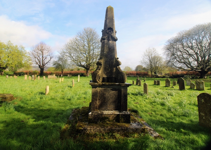
TR 0446 0546 WYE HIGH STREET
(north side)
8/261 Obelisk about 20
metres east of
Church of SS
Gregory and
Martin
GV II
Obelisk to William Godfrey, d. 1766. Double stepped base, originally with
iron railings. Moulded pedestal, with inscriptions to south and fine
relief arms cartouche to east, crowned by obelisk, the whole heavily ivy-
grown.
Listing NGR: TR0544046896
External links are from the relevant listing authority and, where applicable, Wikidata. Wikidata IDs may be related buildings as well as this specific building. If you want to add or update a link, you will need to do so by editing the Wikidata entry.


Other nearby listed buildings
