Approximate Location Map
Large Map »
Latitude: 50.7867 / 50°47'12"N
Longitude: -1.1688 / 1°10'7"W
OS Eastings: 458690
OS Northings: 98899
OS Grid: SZ586988
Mapcode National: GBR 9BV.R8V
Mapcode Global: FRA 87F0.JGK
Plus Code: 9C2WQRPJ+MF
Entry Name: No. 2 Battery
Listing Date: 20 April 1983
Last Amended: 20 December 2016
Grade: II*
Source: Historic England
Source ID: 1276305
English Heritage Legacy ID: 409735
ID on this website: 101276305
Location: Gosport, Hampshire, PO12
County: Hampshire
District: Gosport
Electoral Ward/Division: Alverstoke
Parish: Non Civil Parish
Built-Up Area: Gosport
Traditional County: Hampshire
Lieutenancy Area (Ceremonial County): Hampshire
Church of England Parish: Alverstoke St Mary
Church of England Diocese: Portsmouth
Tagged with: Building
A former gun battery of c1860, built as part of the fortifications to protect Portsmouth Harbour, and known as the Stokes Bay Lines.
A former gun battery of c1860, built as part of the Stokes Bay defences.
MATERIALS: Re-enforced concrete core, with brickwork to the built elevations and stone detailing to embrasures. Gun emplacements have some iron fittings, and internally there are iron and timber fixtures and fittings.
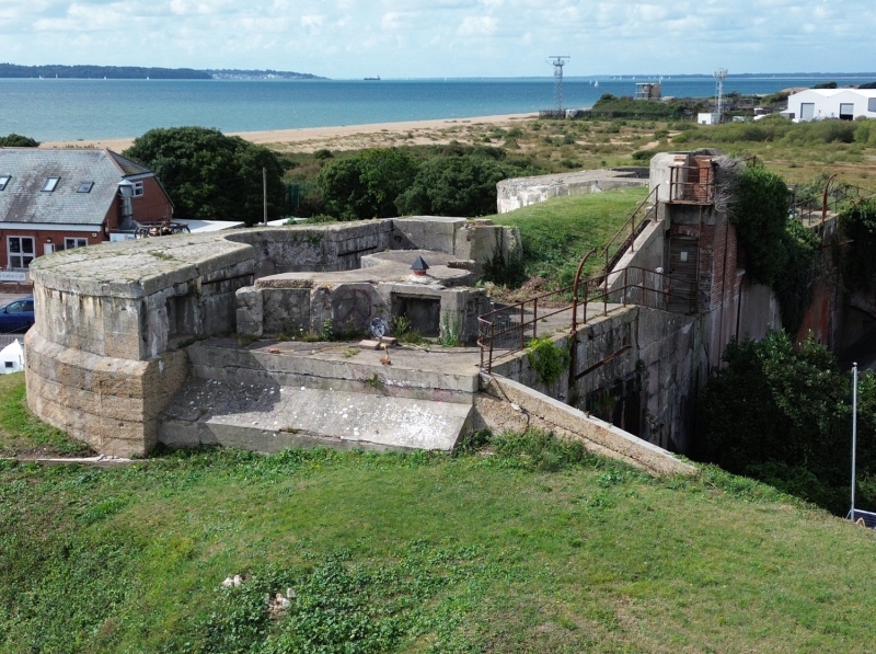
PLAN: the battery is C-shaped in plan and is now predominantly orientated to the south-east. The former parade ground lies behind the ramparts to the north, and the River Alver forms a boundary to the west. The principal brick rampart faces east, and houses the main entrance. The western and southern ramparts are predominantly under grass cover.
EXTERIOR: the principal east brick rampart is symmetrical and consists of three bays over a single storey. It is constructed of brick in an English bond. The outlying bays have a low and large round-headed embrasure with sturdy granite chamfered square architrave to the side and above. The embrasures have deep set multi-paned timber casement windows set behind metal railings. Above each embrasure there is a broad rounded soldier brick arch of six courses with central circular vent. The central bay is similar but the embrasure has been removed and replaced with a recessed door inserted into brick infill. Either side of the entrance there are large round headed shaped sections of render. The top of the rampart face has a short parapet, made from a single course of rounded brick. The roof is grass covered, and has a central concrete open observation post with access to the north.
The southern rampart is hidden behind a grass bank. Towards the top there are the remains of two concrete circular gun emplacements. On the front face there are three visible courses of concrete blocks, the uppermost of which is chamfered in to a parapet. The front face also houses the shell storage area and aperture for the cartridge lifting belt. To the rear there is a lower concrete plinth again with a chamfered outer edge. Inside the bowl of the emplacements there is a circle of locating bolts. At the top of the bank there is a centralised range finding position consisting of a waist height concrete wall with chamfered top. Behind the wall there is a brick built standing platform and the remains of pedestrian ramp leading down to the rear. The western rampart is covered with undergrowth on the western face. On the eastern side there are ten bays of tall single storey brick casemates and stores. They are constructed of brick in an English bond in the form of round headed arches. Each arch is formed of six soldier courses. Some have later timber doors, and some are open. The northern elevation is of two visible storeys and three sections. The western and central sections are brick faced with evidence of former window openings with brick segmental arches. The central section has a rectangular opening at first floor level with stone cill. The eastern section is rendered and blind, and towards the top, has the remnants of a metal crane or gantry. The top of the elevation is a mixture of concrete and patchwork render, and has a protective metal rail running its width.
INTERIOR: the eastern rampart has a brick lining, including a brick vaulted ceiling over each casemate and store. To the north there is a small heavy duty metal door set into later infill brickwork, which provides access in to a small room. The two remaining east facing casemates have timber internal shutters with wrought iron hinges. Either side of the shutters there are narrow vertical timber boards. The shell storage recesses have a plain timber architrave with segmental timber arch and signage. To the south there are brick lined ammunition store rooms with baffled passageways, decorated ventilation apertures, oil lamps recesses, and evidence of the position of the hoist machinery. There is also evidence of later brickwork alterations* and opening up where the high cambered vaulting rests on metal girders*. This area also has some fittings associated with its use as a nuclear bunker including a brick waste point, air filtration system, and heavy duty metal doors.
The west-facing rampart comprises of five casemates separated by five ammunition stores. They are lined in brick with cambered vaulting to the casemates and semi-circular vaulting to the stores. The embrasures are framed in granite, and some have bucket irons, wall rings and door frames. In the most southerly casemate, the filtration system pipework runs along the ceiling and exits to the west.
* Pursuant to s.1 (5A) of the Planning (Listed Buildings and Conservation Areas) Act 1990 (‘the Act’) it is declared that these aforementioned features are not of special architectural or historic interest.
Batteries No. 1 and 2 were built in the Stokes Bay area of Gosport, primarily to defend against a sea-borne attack, and are located at the north-west end of the Stokes Bay Lines. They were part of a system of ramparts, moats and batteries built in the 1860s as part of a major update to the outer defences of Gosport and Portsmouth Harbour. They were built in a strategic position at Browndown Point, which marks the north-western end of Stokes Bay beach; the opposite south-east end was defended by Fort Monckton and Fort Gilkicker (which was built on the site of an earlier fort). Along with the wider defences the batteries were intended to cover the moat, beach, and adjoining deep water anchorage. Their location was partly determined by two earlier batteries; Browndown West and Browndown East, which were built in the early 1850s but were soon recognised as inadequate. Browndown West was rebuilt and later extended, and now survives largely intact as Browndown Battery, within the Browndown firing range. Batteries No. 1 and 2 comprised a connected group of ramparts, casemates, gun emplacements, buildings and related structures which together formed the largest of the Stokes Bay batteries. Unlike the other batteries in the Lines, Battery No. 2 was built with casemated gun positions that were designed to complement those at Fort Gilkicker at the opposite end of the bay.
Battery No. 2 was originally surrounded by its own moat. The primary casemates faced west and east, and two guns faced north-west. There were also two gun emplacements on the southern rampart facing the Solent, which were accessed by a long gun ramp from the parade ground to the north. No. 2 and No. 1 battery were connected by an underground tunnel, and access over the moat was via a bridge in the north-west corner. The battery was originally equipped with up to fifteen smooth-bore eight inch muzzle-loading guns mounted in casemates. In the early 1890s they were replaced with rifled breech-loading seven-inch guns, and at this time the casemates in the south face were replaced with two open positions for seven inch muzzle-loading guns on the parapet. The latter comprised semi-circular concrete emplacements for Moncrieff disappearing gun carriages. The guns and carriages in these positions were replaced again in c1901, with six inch rifled breech loaders, requiring the concrete emplacements to be in-filled and raised. A contemporary concrete command post remains on the parapet between the two emplacements, but these later guns may have been withdrawn as early as 1902. In the late 1890s the other guns were replaced with fixed Maxim machine guns, mounted in the west and east facing casemates. The southern and western embrasures in front of the casemates were later in-filled to create the current (2016) form of the embankment, presumably when these casemates were no longer used as gun positions. All guns were withdrawn by 1907.
When operational, the battery had two shell stores (holding 890 rounds), six cartridge stores (holding approximately 1900 rounds), and a small arms store. Ammunition was delivered to the overhead guns using mechanised cartridge lifting belts. By 1891, two of the cartridge stores were removed and the storage areas underwent continuous alteration through the late C19 and early C20, reflecting changing armament technology. In the 1890s additional storage buildings were added in the parade ground and the northern casemate in the west face was adapted to provide married quarters.
Gosport Borough Council purchased the battery in 1932 from the Home Office for £1,500, and in 1933 the parade ground was cleared of buildings and became a caravan park. In 1939 the council moved their records from the town hall to the battery for safe storage. For the remainder of the Second World War the battery was once again under military control, and by 1947 it was being used by the Special Armament Development Establishment (SADE) based in Fort Gomer. In 1950 the battery was in use by the 7th Royal Tank Regiment Amphibious Wing, but by November 1951 the military handed the site back to the council. The moat was filled in 1956, and presumably around this time the officers married-quarters and the access bridge were demolished. The channel connecting the River Alver to the sea remains and forms the western boundary.
In 1982 Gosport Council converted the casemates and magazines of the battery into a
nuclear bunker (or Civil Defence Command Post) at a cost of £30,000. The eastern central gun embrasure was converted to a doorway, and the remaining embrasures had blanks inserted, or were in-filled with brick. At some point, the western casemates and stores have had their wooden partitions removed allowing them to be used for storage by the council and caravan park residents. In 2011 Gosport Borough Council agreed a long lease for the use of the site by the Historical Diving Society as a museum.
No. 2 Battery, c1860, built as part of the fortifications to protect Portsmouth Harbour, is listed at Grade II* for the following principal reasons:
* Historic interest: this is a vital building in our understanding of the evolving defence of Portsmouth over the past 500 years, but particularly in the Victorian period when fear of a French invasion was high, and technological advances in armaments were very rapid. It also helps illustrate how local government prepared to survive a nuclear attack;
* Rarity: it is the largest and most technologically innovative battery at Stokes Bay and designed from the outset to have embrasures. More latterly it had gun hoists to supply gun emplacements from fortified ammunition stores;
* Survival: it survives well and is the only purpose built Stokes Bay battery with substantial above ground structure;
* Design and form: the original function of the building is clearly legible, and although altered, the specialised form remains legible through each technological and functional update;
* Group value: the battery is linked to No. 1 Battery via a disused tunnel, and it is an integral part of the wider Stokes Bay defensive strategy, which also includes Fort Monckton and Fort Gilkicker.
External links are from the relevant listing authority and, where applicable, Wikidata. Wikidata IDs may be related buildings as well as this specific building. If you want to add or update a link, you will need to do so by editing the Wikidata entry.


Other nearby listed buildings
