Approximate Location Map
Large Map »
Latitude: 50.9619 / 50°57'42"N
Longitude: 0.3777 / 0°22'39"E
OS Eastings: 567069
OS Northings: 120748
OS Grid: TQ670207
Mapcode National: GBR NTD.LB2
Mapcode Global: FRA C6PK.LZ7
Plus Code: 9F22X96H+Q3
Entry Name: The Observatory
Listing Date: 3 August 1961
Grade: II*
Source: Historic England
Source ID: 1277117
English Heritage Legacy ID: 292428
ID on this website: 101277117
Location: Rother, East Sussex, TN32
County: East Sussex
District: Rother
Civil Parish: Brightling
Traditional County: Sussex
Lieutenancy Area (Ceremonial County): East Sussex
Church of England Parish: Brightling St Thomas a Becket
Church of England Diocese: Chichester
Tagged with: Architectural structure
TQ 62 SE BRIGHTLING BURWASH ROAD
11/20 The Observatory
3.8.61
II*
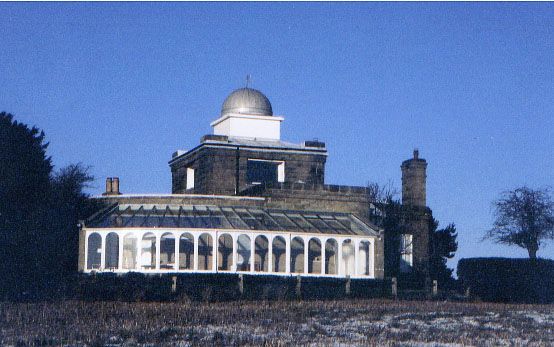
Like Brightling Needle, this stands on a high spot. It was designed by Sir Robert
Smirke in the early C19 for John Fuller of Brightling Park. The main building
is T-shaped and of only 1 storey. Ashlar. Cornice and parapet. The east end
is splayed and contains 2 windows with a tall chimney stack above the flat side
between. The north and south walls of the east wing have slits for telescopes
which are now closed with narrow double doors. The north and south wings have
1 window each and the north wing a doorway with ashlar pilasters and pediment.
Above the intersection of the 3 wings is a second storey with 1 window to each
front, a cornice and parapet over and inset within the latter a squat square turret
of painted brick surmounted by a lead dome with a tiny window on the north side.
On the west side is a semicircular curtain wall with the thickness of one room
behind it making a semicircular court-yard between this and the entrance to the
main building under the tower which has a doorway and window combined.
Listing NGR: TQ6706920748
External links are from the relevant listing authority and, where applicable, Wikidata. Wikidata IDs may be related buildings as well as this specific building. If you want to add or update a link, you will need to do so by editing the Wikidata entry.


Other nearby listed buildings
