Approximate Location Map
Large Map »
Latitude: 52.8654 / 52°51'55"N
Longitude: -1.1157 / 1°6'56"W
OS Eastings: 459626
OS Northings: 330129
OS Grid: SK596301
Mapcode National: GBR 9L3.6RY
Mapcode Global: WHDHC.T7WP
Plus Code: 9C4WVV8M+4P
Entry Name: Pair of Gate Piers and Walls Extending Around Bunny Park
Listing Date: 13 November 1986
Grade: II
Source: Historic England
Source ID: 1277791
English Heritage Legacy ID: 430458
ID on this website: 101277791
Location: Rushcliffe, Nottinghamshire, NG11
County: Nottinghamshire
District: Rushcliffe
Civil Parish: Bunny
Traditional County: Nottinghamshire
Lieutenancy Area (Ceremonial County): Nottinghamshire
Church of England Parish: Bunny with Bradmore
Church of England Diocese: Southwell and Nottingham
Tagged with: Gatepost
BUNNY WYSALL ROAD
SK 53 SE and (north side)
SK 52 NE extending to
Keyworth Lane
and Fairham
Brook Lane
5/48, 7/48 Pair of Gate Piers
and walls extending
around Bunny Park
II
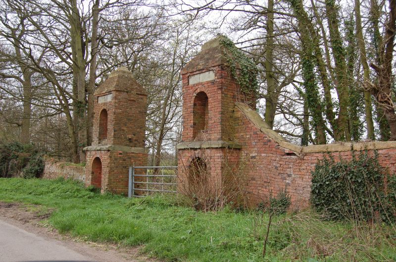
Pair of gate piers and walls. Early C18. Designed by and built
for Sir Thomas Parkyns of Bunny Hall. Red brick, some blue brick
and ashlar. Single pair of red brick gate piers on Wysall Road,
each of 2 stages, the lower projecting from the upper with
chamfered ashlar dividing band. Each stage with single round
arched niche, over those of the top stage are single recessed
ashlar panels. Stepped brick leading to ashlar coping with
single ashlar pineapple finials. Either side are single ashlar
coped brick walls which slope down to meet the wall of about 2
metres high which extends around the Park and is built upon
segmental arches. The wall extends from the right pier for
about one-quarter of a mile north and then about half a mile west
and from the left pier for about one-quarter of a mile south, it
then curves round and extends for about a further half a mile
west terminating in a single pair of red brick gate piers. The
wall is broken in a few places by gateways and damage. On the
east side is a single small seated shelter built into the wall.
This wall was built to enclose the Park of Bunny Hall. Sir
Thomas Parkyns Bart. (c.1662-1741) carried out improvements to
and rebuilt almost all of Bunny to his own designs.
Listing NGR: SK5962630129
External links are from the relevant listing authority and, where applicable, Wikidata. Wikidata IDs may be related buildings as well as this specific building. If you want to add or update a link, you will need to do so by editing the Wikidata entry.


Other nearby listed buildings
