Approximate Location Map
Large Map »
Latitude: 51.3522 / 51°21'7"N
Longitude: 1.0238 / 1°1'25"E
OS Eastings: 610646
OS Northings: 165800
OS Grid: TR106658
Mapcode National: GBR TX7.1NN
Mapcode Global: VHKJR.P8LQ
Plus Code: 9F33922F+VG
Entry Name: 1, Forge Lane
Listing Date: 20 May 1977
Grade: II
Source: Historic England
Source ID: 1278050
English Heritage Legacy ID: 170822
ID on this website: 101278050
Location: Lower Island, Canterbury, Kent, CT5
County: Kent
District: Canterbury
Electoral Ward/Division: Gorrell
Parish: Non Civil Parish
Built-Up Area: Whitstable
Traditional County: Kent
Lieutenancy Area (Ceremonial County): Kent
Tagged with: Building
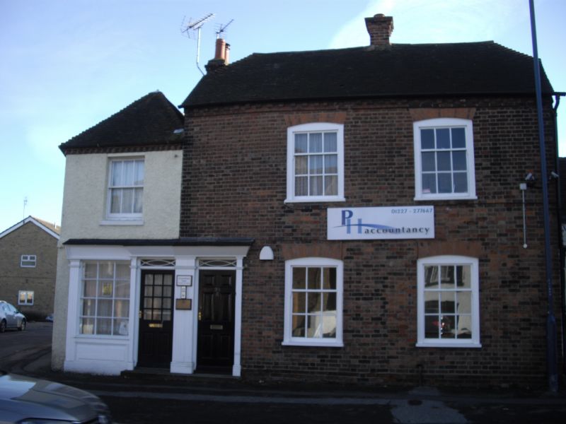
FORGE LANE
1.
5273 (South-West Side)
No 1
TR 16 NW 4/22
II
Includes No 99A Canterbury Road (qv). Early C19 2 storey building. Brick built
pebbledashed front, zig-zag brick dentil course and old clay tiled roof. 1st floor
windowa box sashes complete. Shop window and door ground floor on both elevations.
Pilasters and glazing bard intact.
Listing NGR: TR1066565780
External links are from the relevant listing authority and, where applicable, Wikidata. Wikidata IDs may be related buildings as well as this specific building. If you want to add or update a link, you will need to do so by editing the Wikidata entry.


Other nearby listed buildings
