Approximate Location Map
Large Map »
Latitude: 53.7217 / 53°43'18"N
Longitude: -2.057 / 2°3'25"W
OS Eastings: 396334
OS Northings: 425033
OS Grid: SD963250
Mapcode National: GBR GT2D.GM
Mapcode Global: WHB8D.CQP7
Plus Code: 9C5VPWCV+M5
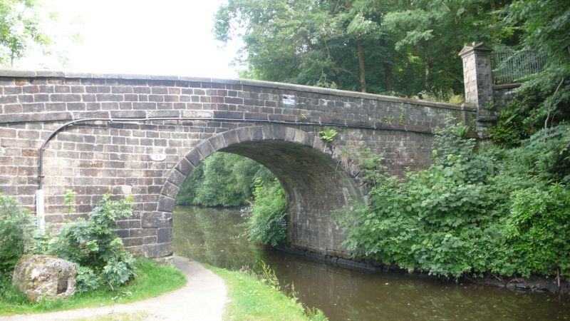
Entry Name: Stoodley Bridge
Listing Date: 22 February 1984
Grade: II
Source: Historic England
Source ID: 1278356
English Heritage Legacy ID: 405990
ID on this website: 101278356
Location: Eastwood, Calderdale, West Yorkshire, OL14
County: Calderdale
Civil Parish: Todmorden
Traditional County: Yorkshire
Lieutenancy Area (Ceremonial County): West Yorkshire
Church of England Parish: Todmorden St Mary
Church of England Diocese: Leeds
Tagged with: Bridge
SD 92NE TODMORDEN (former M.B.) STOODLEY LANE
3/297 Stoodley Bridge
G.V. II
Road bridge over the canal. Early C19. Hammer-dressed stone, single span
horse-shoe elliptical arch. Rusticated voussoirs. Band, parapet with thin flag
cappings. Piers to either side break forward slightly.
Listing NGR: SD9633425033
External links are from the relevant listing authority and, where applicable, Wikidata. Wikidata IDs may be related buildings as well as this specific building. If you want to add or update a link, you will need to do so by editing the Wikidata entry.


Other nearby listed buildings
