Approximate Location Map
Large Map »
Latitude: 50.8352 / 50°50'6"N
Longitude: -3.2755 / 3°16'31"W
OS Eastings: 310277
OS Northings: 104734
OS Grid: ST102047
Mapcode National: GBR LT.WL0P
Mapcode Global: FRA 460W.RQ8
Plus Code: 9C2RRPPF+3R
Entry Name: Blackmores Blackmores, Sometimes Known As Pennywain
Listing Date: 27 January 1989
Grade: II
Source: Historic England
Source ID: 1281226
English Heritage Legacy ID: 87064
ID on this website: 101281226
Location: Broadhembury, East Devon, EX14
County: Devon
District: East Devon
Civil Parish: Broadhembury
Traditional County: Devon
Lieutenancy Area (Ceremonial County): Devon
Church of England Parish: Broadhembury St Andrew, Apostle and Martyr
Church of England Diocese: Exeter
Tagged with: Architectural structure Thatched cottage
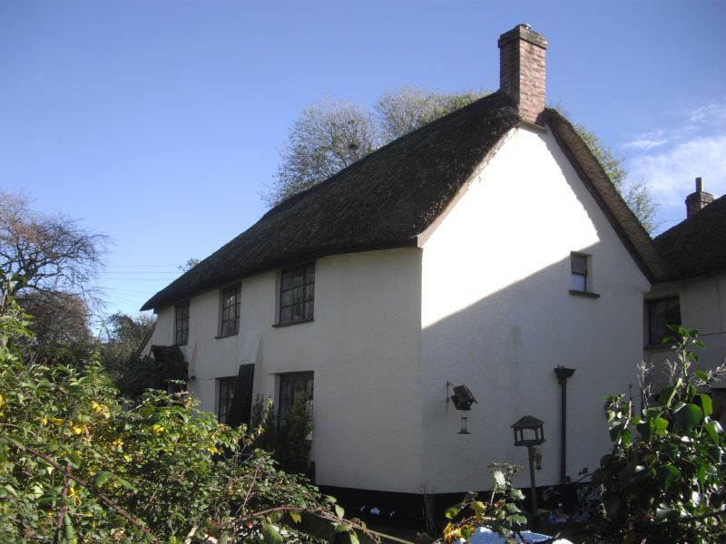
BROADHEMBURY BROADHEMBURY CROSS, Broadhembury
ST 00 NE
5/62 Blackmores, sometimes known as
Pennywain
GV II
Small estate house. Possibly of C17 origins but altered subsequently. Creamwashed
and rendered, probably cob on stone rubble; thatched roof with a plain ridge, gabled
at ends; rear lateral stack, right end stack.
Plan: Single depth plan, probably 2 rooms wide. A C17 moulded doorframe at the left
end may be re-sited but, if in situ, suggests that the house may have extended
further to the left at one time: the existing house may be the passage, hall and
inner of a 3 room and passage plan house, the lower end reduced to an outshut. The
present front door is to the right of the C17 doorframe.
Exterior: 2 storeys. C20 plank front door to left of centre with a gabled porch
hood, C17 moulded doorframe to the left. 2 3-light timber ground floor casements,
possibly C19, with small panes, 3 first floor C19 or C20 3-light timber casements
with glazing bars.
Interior: Not inspected. Said to have no exposed carpentry.
Set forward from but adjacent to Vicarage Cottage. At the east end of an outstanding
estate village characterized by cob and thatch.
Listing NGR: ST1027604732
External links are from the relevant listing authority and, where applicable, Wikidata. Wikidata IDs may be related buildings as well as this specific building. If you want to add or update a link, you will need to do so by editing the Wikidata entry.


Other nearby listed buildings
