Approximate Location Map
Large Map »
Latitude: 51.3764 / 51°22'34"N
Longitude: 1.3796 / 1°22'46"E
OS Eastings: 635294
OS Northings: 169567
OS Grid: TR352695
Mapcode National: GBR WZZ.MM1
Mapcode Global: VHLG6.VNPR
Plus Code: 9F3399GH+GR
Entry Name: Salmestone Grange Including Chapel
Listing Date: 10 April 1951
Grade: II*
Source: Historic England
Source ID: 1281452
English Heritage Legacy ID: 356636
Also known as: Salmestone Grange
ID on this website: 101281452
Location: Thanet, Kent, CT9
County: Kent
District: Thanet
Electoral Ward/Division: Salmestone
Parish: Non Civil Parish
Built-Up Area: Margate
Traditional County: Kent
Lieutenancy Area (Ceremonial County): Kent
Tagged with: Architectural structure
NASH ROAD
1.
1380
Salmestone Grange
including chapel
TR 36 NE 12/71 10.4.51.
II*
2.
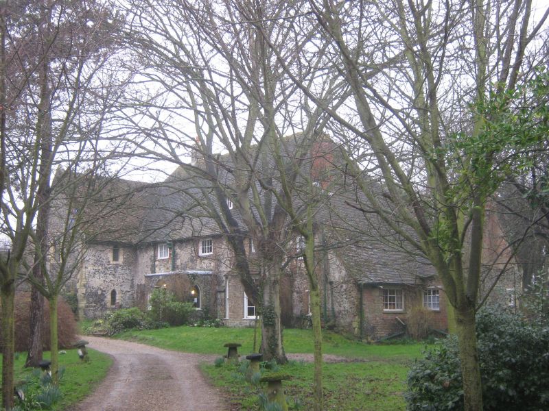
A monastic grange which once belonged to St Augustine's Canterbury. The
North East end of the building was converted into a farmhouse in the C17.
This was the Refectory built about 1320. It has 2 storeys and attic, 4
windows and 1 dormer. The walls are of rubble and flints with long and
short stone quoins. Brick window dressings. Casements or sliding sashes.
A curved bay of brown brick containing 2 sash windows and with a tiled roof
over it has been built out over the ground floor. Porch added with 6 panel
moulded door.
This section of the grange retains the original Refectory fireplace and a
king post roof.
The centre portion is of 2 storeys flint faced with tiled roof and stone
quoins. Double lancet on 1st floor. 2 on ground floor. Crypt with 2 bay
simple vaulting. The kitchens retain a bread oven by the side of the fireplace.
The South West end of the buildings fell into ruin and was restored before the
Second World War. The east front of this end of the building, which projects
beyond the Refectory building, has gables, the North East one C13 with lancet
windows, the centre one largely modern restoration, the South West one C14.
Walls of flint and rubble. This part contained the Dormitory and the 1st
floor has double lancet windows with trefoil heads and stone seats.
On this side there is a wall of 2 storeys with stone base and flint top. Stone
surrounds. Blocked lancets and 1 Tudor arch. Through the cloisters, of flint
with brick arches the chapel is reached. It was consecrated in 1326 and is of
knapped flint and rubble and has a crown post roof, with moulded tie beams,
a 2 bay nave, piscina and corbels.
Listing NGR: TR3529469567
External links are from the relevant listing authority and, where applicable, Wikidata. Wikidata IDs may be related buildings as well as this specific building. If you want to add or update a link, you will need to do so by editing the Wikidata entry.


Other nearby listed buildings
