Approximate Location Map
Large Map »
Latitude: 51.4818 / 51°28'54"N
Longitude: -2.5293 / 2°31'45"W
OS Eastings: 363342
OS Northings: 176006
OS Grid: ST633760
Mapcode National: GBR CQ7.SN
Mapcode Global: VH88P.30QV
Plus Code: 9C3VFFJC+P7
Entry Name: Numbers 11, 13 and 15 and Attached Garden Wall
Listing Date: 8 January 1959
Last Amended: 30 December 1994
Grade: II*
Source: Historic England
Source ID: 1282219
English Heritage Legacy ID: 379976
ID on this website: 101282219
Location: Fishponds, Bristol, BS16
County: City of Bristol
Electoral Ward/Division: Frome Vale
Parish: Non Civil Parish
Built-Up Area: Bristol
Traditional County: Gloucestershire
Lieutenancy Area (Ceremonial County): Bristol
Church of England Parish: Fishponds St Mary
Church of England Diocese: Bristol
Tagged with: Architectural structure
BRISTOL
ST67NW MANOR ROAD, Fishponds
901-1/54/1270 (North side)
08/01/59 Nos.11, 13 AND 15
and attached garden wall
(Formerly Listed as:
MANOR ROAD
Nos.11-15 (Odd))
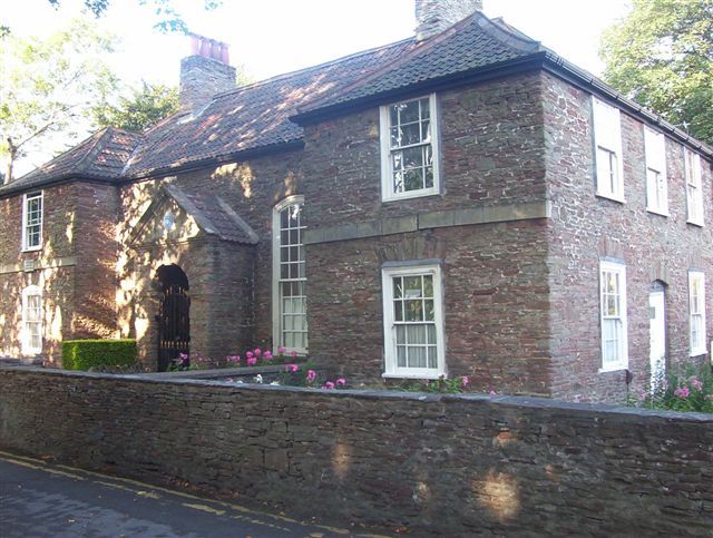
GV II*
House and former school. c1720. Converted into schoolroom in
later C18. Thin Pennant rubble with rubble quoins and
limestone dressings, 2 rubble ridge stacks and a double Roman
hipped roof with cross wings at each end. H-shaped
single-depth plan with a central hall and attached end houses.
2 storeys; 4-window range.
Symmetrical front with 2 wings at either end. A central
pedimented porch contains a round-arched doorway with a key,
impost bands and benched niches inside, and a 4-plank door
with ovolo mouldings in a pegged frame with a segmental head.
Full height, segmental-arched windows either side, with 16/16
pane sashes with thick bars.
Projecting 2-storey wings have 6/6 pane sashes in flush boxes
on the right, C20 replacements on the left. Plat band, with on
left a plaque inscribed HANNAH MORE/ BORNE HERE/ FEB 2 1745.
Ridge stacks to the sides of the central bay. Similar doorless
rear elevation.
Right-hand return is a 3-window-range symmetrical front with a
similar door, flat rubble window heads and first-floor windows
beneath the wall plate.
INTERIOR not inspected but noted as having a central hall with
fireplaces at each end.
SUBSIDIARY FEATURES: low rubble wall to front and side areas.
HISTORICAL NOTE: birthplace of Hannah More, the notable
educational reformer, and a rare early schoolroom in its own
right. Graded for its historical and architectural importance.
Has group value with the nearby Church of St Mary (qv).
Listing NGR: ST6334276006
External links are from the relevant listing authority and, where applicable, Wikidata. Wikidata IDs may be related buildings as well as this specific building. If you want to add or update a link, you will need to do so by editing the Wikidata entry.


Other nearby listed buildings
