Approximate Location Map
Large Map »
Latitude: 51.4567 / 51°27'23"N
Longitude: -2.6266 / 2°37'35"W
OS Eastings: 356562
OS Northings: 173261
OS Grid: ST565732
Mapcode National: GBR C1J.0P
Mapcode Global: VH88M.FN96
Plus Code: 9C3VF94F+M9
Entry Name: Clifton Observatory
Listing Date: 4 March 1977
Grade: II*
Source: Historic England
Source ID: 1282362
English Heritage Legacy ID: 379207
ID on this website: 101282362
Location: Durdham Down and Clifton Down, Hotwells, Bristol, BS8
County: City of Bristol
Electoral Ward/Division: Clifton
Parish: Non Civil Parish
Built-Up Area: Bristol
Traditional County: Gloucestershire
Lieutenancy Area (Ceremonial County): Bristol
Church of England Parish: Clifton Christ Church with Emmanuel
Church of England Diocese: Bristol
Tagged with: Observation tower
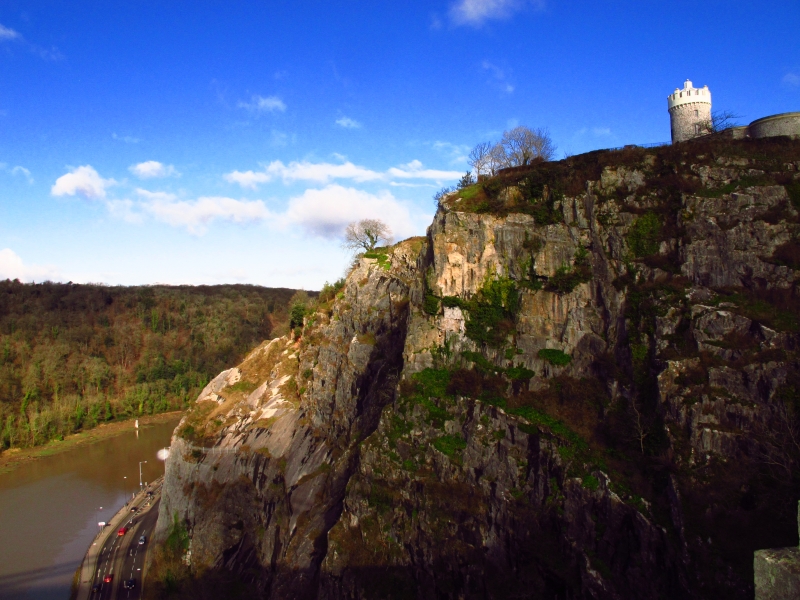
BRISTOL
ST5673SE CLIFTON DOWN, Clifton
901-1/7/749 (West side)
04/03/77 Clifton Observatory
II*
Former windmill, now camera obscura. C18. Camera and extension
of 1828 and 1835 by a Mr West. Carboniferous limestone rubble
with limestone dressings, lead roof to tower, roofless side
block. Single-depth plan.
3-stage round tower with single-storey; 4-window side block.
The battered tower has a first-floor casement window, and
tall, moulded brackets to a rendered top storey containing the
camera obscura with crenellations and casements in the
embrasures. Tudor-arched doorway to the roofless side block,
which has a curved end and 2 segmental-headed windows; the
rear has two 4-centre arched rear windows with torus mouldings
and casements with margin panes, and paired right-hand 2-light
windows.
INTERIOR: a winder stair up to the camera obscura in the roof,
and down into a tunnel leading to Ghyston's Cave, in the side
of the gorge.
HISTORICAL NOTE: the windmill was damaged by fire in 1777.
William West leased the mill for conversion into an
observatory in 1828. In 1835 he was granted an extra piece of
land adjacent to the tower on which he built a new
astronomical observatory with a revolving dome and telescope
"to allow unrestricted observation of the heaven". Next to
this was a large room with various astronomical maps, globes
and instruments, intended for occasional use as a lecture
room. The tower was also altered in 1835, by the rebuilding of
the wooden balcony in store and the fitting of the camera
obscura. West also excavated an underground passage to
Ghyston's Cave, opened 1837.
(Chilcott: History of Bristol: Bristol: 1844-).
Listing NGR: ST5656273261
External links are from the relevant listing authority and, where applicable, Wikidata. Wikidata IDs may be related buildings as well as this specific building. If you want to add or update a link, you will need to do so by editing the Wikidata entry.


Other nearby listed buildings
