Approximate Location Map
Large Map »
Latitude: 53.541 / 53°32'27"N
Longitude: -2.1096 / 2°6'34"W
OS Eastings: 392832
OS Northings: 404935
OS Grid: SD928049
Mapcode National: GBR FWQH.2C
Mapcode Global: WHB9B.K8M7
Plus Code: 9C5VGVRR+C5
Entry Name: Union Street United Reformed and Methodist Church
Listing Date: 8 March 1993
Grade: II
Source: Historic England
Source ID: 1282575
English Heritage Legacy ID: 388952
ID on this website: 101282575
Location: Rhodes Bank, Oldham, Greater Manchester, OL1
County: Oldham
Electoral Ward/Division: Coldhurst
Parish: Non Civil Parish
Built-Up Area: Oldham
Traditional County: Lancashire
Lieutenancy Area (Ceremonial County): Greater Manchester
Church of England Parish: Oldham St Mary with St Peter
Church of England Diocese: Manchester
Tagged with: Protestant church building
OLDHAM
SD9204NE UNION STREET
780-1/6/87 (North side)
Union Street United Reformed and
Methodist Church
GV II
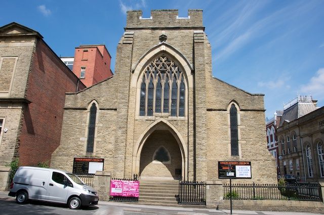
United Reformed Church, formerly Congregational chapel. 1877.
Rusticated rubble, coursed and squared in small blocks, with
slate roof. Tower, nave with 2 aisles. Squat central tower in
south wall with 6-light Decorated window with hoodmould, and
doors recessed to east and west within wide plain stepped
Early English arch to porch. Enriched trefoiled window in
south wall inside porch. Buttresses to tower, which has
embattled parapet. Shallow copings to aisles each side of
tower, with foiled lancet windows in south walls, the east and
west walls divided by buttresses into 4 bays, each with foiled
lancet window. Wood clerestory over, with continuous trefoiled
lights. Northern gable has small 3-light Decorated window, and
hipped roofed single-storeyed rooms projecting beyond, with
paired 2-light windows. Cast-iron railings and gates carried
on low plinth wall between stone piers to south and east.
(Worrall: Oldham and District Directory: Oldham: 1880-).
Listing NGR: SD9283204935
External links are from the relevant listing authority and, where applicable, Wikidata. Wikidata IDs may be related buildings as well as this specific building. If you want to add or update a link, you will need to do so by editing the Wikidata entry.


Other nearby listed buildings
