Approximate Location Map
Large Map »
Latitude: 51.9976 / 51°59'51"N
Longitude: -0.9907 / 0°59'26"W
OS Eastings: 469391
OS Northings: 233718
OS Grid: SP693337
Mapcode National: GBR 9XQ.NCS
Mapcode Global: VHDT8.S14Z
Plus Code: 9C3XX2X5+2P
Entry Name: 39, Nelson Street
Listing Date: 3 April 1973
Grade: II
Source: Historic England
Source ID: 1282688
English Heritage Legacy ID: 377232
ID on this website: 101282688
Location: Buckingham, Buckinghamshire, MK18
County: Buckinghamshire
Civil Parish: Buckingham
Built-Up Area: Buckingham
Traditional County: Buckinghamshire
Lieutenancy Area (Ceremonial County): Buckinghamshire
Church of England Parish: Buckingham
Church of England Diocese: Oxford
Tagged with: Building
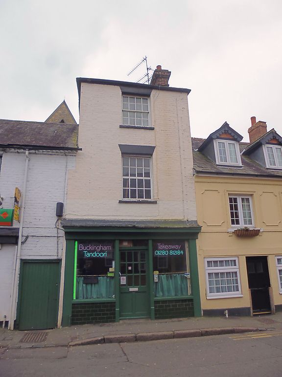
BUCKINGHAM
SP6933 NELSON STREET
879-1/6/134 (East side)
03/04/73 No.39
GV II
Shop and dwelling. Early C19 altered C20. Colour-washed brick,
hipped slate roof and brick lateral stack to right. 1-unit
plan. 3-storey, 1-window range. C19 pilastered wood shop
front, altered C20. 16-pane sash windows to 1st and 2nd floors
with rendered, flat-arched heads.
Listing NGR: SP6939333715
External links are from the relevant listing authority and, where applicable, Wikidata. Wikidata IDs may be related buildings as well as this specific building. If you want to add or update a link, you will need to do so by editing the Wikidata entry.


Other nearby listed buildings
