Approximate Location Map
Large Map »
Latitude: 53.8749 / 53°52'29"N
Longitude: -1.8811 / 1°52'51"W
OS Eastings: 407915
OS Northings: 442079
OS Grid: SE079420
Mapcode National: GBR HR9M.KQ
Mapcode Global: WHC8V.2VJV
Plus Code: 9C5WV4F9+WH
Entry Name: Shop Approximately 2 Metres to North East of East Riddlesden Hall
Listing Date: 23 February 1955
Last Amended: 4 December 1986
Grade: II
Source: Historic England
Source ID: 1283458
English Heritage Legacy ID: 338101
ID on this website: 101283458
Location: Riddlesden, Bradford, West Yorkshire, BD20
County: Bradford
Civil Parish: Keighley
Built-Up Area: Keighley
Traditional County: Yorkshire
Lieutenancy Area (Ceremonial County): West Yorkshire
Church of England Parish: Riddlesden St Mary the Virgin
Church of England Diocese: Leeds
Tagged with: Architectural structure
KEIGHLEY BRADFORD ROAD
SE 04 SE (south side, off)
5/15 Riddlesden
23.2.55 Shop approx 2 metres to
north-east of East
Riddlesden Hall (formerly
listed as 'farm building
directly north-east
of Hall)
GV II
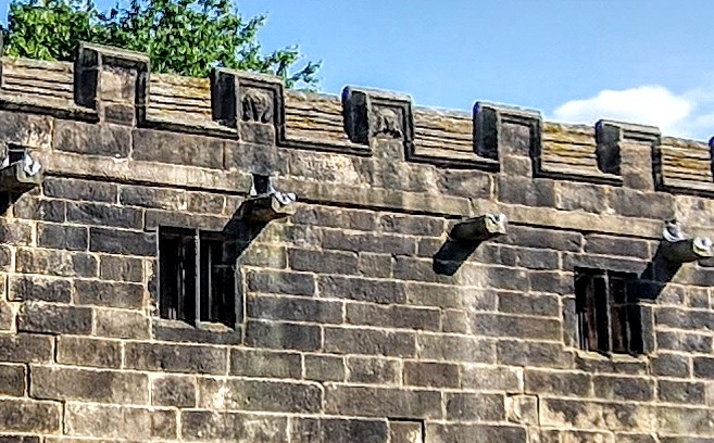
Outbuilding now National Trust shop. Dated 1642. Coursed dressed stone, stone
slate roof. 2 storeys, 5 lst-floor windows. Chamfered plinth. 4 chamfered
doorways with decorative heads, one initialled and dated. 2-light double-chamfered
mullion windows above. Row of 11 gutter spouts. Embattled parapet with masks of
Charles I and his Queen and motto 'Vive le Roy'. Raised verges with ashlar coping
and finials. External stack with corniced, diamond-set flue to left gable. Rear:
door and 3-light windows to ground floor, some altered; 2-light windows above.
Flight of steps on left lead to lst-floor door in right gable. Right gable also
has a 4-light window. Interior: fireplace at left end with moulded jambs and
decorated lintel; traces of decorative plasterwork. The building may originally
have functioned as a range of additional lodgings (guest accommodation) (cf Royal
Commission on Historical Monuments, Rural Houses of the Lancashire Pennines 1560-
1760 (1985) , p55).
Listing NGR: SE0791542079
External links are from the relevant listing authority and, where applicable, Wikidata. Wikidata IDs may be related buildings as well as this specific building. If you want to add or update a link, you will need to do so by editing the Wikidata entry.


Other nearby listed buildings
