Approximate Location Map
Large Map »
Latitude: 51.6047 / 51°36'16"N
Longitude: -1.6697 / 1°40'10"W
OS Eastings: 422974
OS Northings: 189588
OS Grid: SU229895
Mapcode National: GBR 5WB.BPP
Mapcode Global: VHC0R.0XPR
Plus Code: 9C3WJ83J+V4
Entry Name: Sandhill Farmhouse
Listing Date: 31 October 1983
Grade: II
Source: Historic England
Source ID: 1284132
English Heritage Legacy ID: 250615
ID on this website: 101284132
Location: Vale of White Horse, Oxfordshire, SN6
County: Oxfordshire
District: Vale of White Horse
Civil Parish: Shrivenham
Traditional County: Berkshire
Lieutenancy Area (Ceremonial County): Oxfordshire
Church of England Parish: Shrivenham with Watchfield and Bourton
Church of England Diocese: Oxford
Tagged with: Farmhouse
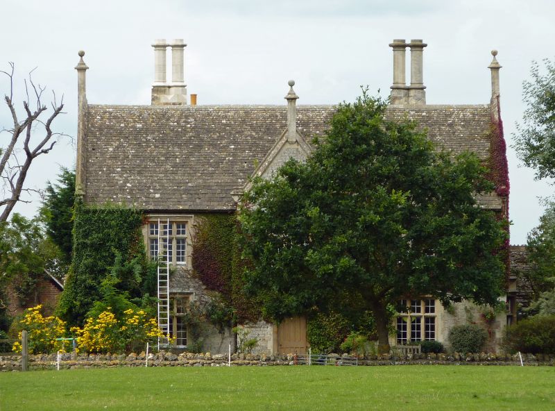
1. SHRIVENHAM HIGHWORTH ROAD
Sandhill Farmhouse
SU 28 NW 4/69
II
2.
C18 rebuilding of an earlier house, a gabled rubble stone section of which survives to
the rear, with a Tudor Gothic addition similar in style to Beckett Hall dated 1841
beneath its central gable. The C18 rebuilt range is of brick with a gabled machine
tiled roof and 2 brick stacks. The C19 wing is of coursed and squared rubble stone
with stone dressings and a gabled stone tiled roof with 2 tall stone stacks with
paired polygonal chimneys. The 2 sections form a T shaped plan. C18 range of
2 storeys, 7 bays with 2 light, 8 pane casements to upper floor and 2 light, 3 pane
casements to lower floor. C19 addition of 2 storeys and attic, 3 bays. W front of
3 light cross mullion windows with small panes under dripstones either side of a
central projecting gabled bay with a plank and batten door under a Tudor arch and
above the 1st floor window, a datestone and coat of arms. The gable, matching
2 others to the N and S ends has kneelers and a central finial. The S end has a
projecting bay window to the ground floor. A thick growth of Virginia creeper covers
the W front.
Listing NGR: SU2297489588
External links are from the relevant listing authority and, where applicable, Wikidata. Wikidata IDs may be related buildings as well as this specific building. If you want to add or update a link, you will need to do so by editing the Wikidata entry.


Other nearby listed buildings
