Approximate Location Map
Large Map »
Latitude: 51.6246 / 51°37'28"N
Longitude: -1.084 / 1°5'2"W
OS Eastings: 463507
OS Northings: 192152
OS Grid: SU635921
Mapcode National: GBR B27.2RK
Mapcode Global: VHCYJ.5F9F
Plus Code: 9C3WJWF8+RC
Entry Name: Wall Approximately 20 Metres West of the Old Mansion
Listing Date: 28 November 1985
Grade: II
Source: Historic England
Source ID: 1285716
English Heritage Legacy ID: 247797
ID on this website: 101285716
Location: South Oxfordshire, OX10
County: Oxfordshire
District: South Oxfordshire
Civil Parish: Ewelme
Traditional County: Oxfordshire
Lieutenancy Area (Ceremonial County): Oxfordshire
Church of England Parish: Ewelme
Church of England Diocese: Oxford
Tagged with: Wall
EWELME COTTESMORE LANE
SU69SM (West side)
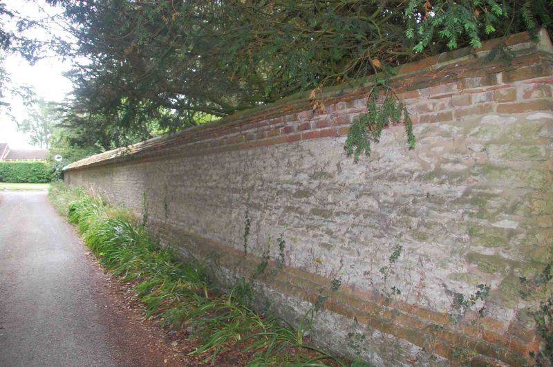
2/88 Wall approx. 20m. W of The Old
Mansion
GV II
Wall. Probably late C17 with C19 coping. Red brick base; limestone rubble; C19
tiles to coping. Quoined brick pier to left.
Listing NGR: SU6350792152
External links are from the relevant listing authority and, where applicable, Wikidata. Wikidata IDs may be related buildings as well as this specific building. If you want to add or update a link, you will need to do so by editing the Wikidata entry.


Other nearby listed buildings
