Approximate Location Map
Large Map »
Latitude: 53.0314 / 53°1'52"N
Longitude: -1.0294 / 1°1'45"W
OS Eastings: 465186
OS Northings: 348671
OS Grid: SK651486
Mapcode National: GBR 9J2.YB1
Mapcode Global: WHFHS.522F
Plus Code: 9C5W2XJC+G6
Entry Name: Pigeoncote and Attached Garage and Walls at Poplars
Listing Date: 13 May 1986
Grade: II
Source: Historic England
Source ID: 1286073
English Heritage Legacy ID: 242092
ID on this website: 101286073
Location: Epperstone, Newark and Sherwood, Nottinghamshire, NG14
County: Nottinghamshire
District: Newark and Sherwood
Civil Parish: Epperstone
Built-Up Area: Epperstone
Traditional County: Nottinghamshire
Lieutenancy Area (Ceremonial County): Nottinghamshire
Church of England Parish: Epperstone
Church of England Diocese: Southwell and Nottingham
Tagged with: Dovecote
SK 64 NE
9/36
EPPERSTONE
CHAPEL LANE
(west side)
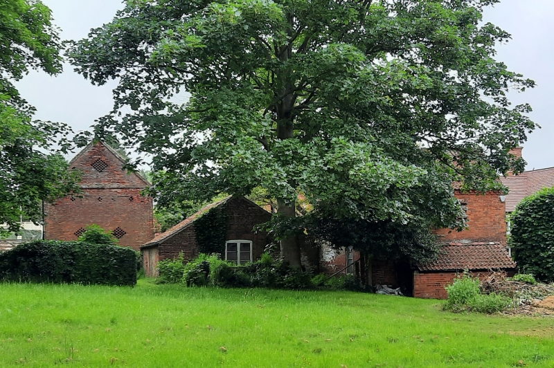
Pigeoncote and attached garage and walls at Poplars
G.V.
II
Pigeoncote, incorporating stable and granary and attached garage
and walls. Early C18, C19. Red brick. Pigeoncote with plain
tile and pantile roof. Crow stepped gables with kneelers.
Dentil eaves. 2 storeys, 2 bays. 2 doorways with plank stable
doors. Rear has a single storey lean-to and above 3 rows of
flight perches with openings for birds. Projecting from the
front right is a single storey red brick and pantile C19
outbuilding, now garage with large doorway with part glazed
doors, flanked by single glazing bar sashes. Projecting from the
right is a red brick wall with shaped brick coping and extending
for 7 metres where it terminates in a single brick pier with
ashlar coping, there is a similar brick pier forming a gateway
then the wall continues for a further single metre where it turns
at a right angle and extends for a further 11 metres being coped
with shaped blue brick then broken by an ashlar trough and
continuing being ashlar coped with 5 feeding bays to the crew
yard side.
Listing NGR: SK6518648671
External links are from the relevant listing authority and, where applicable, Wikidata. Wikidata IDs may be related buildings as well as this specific building. If you want to add or update a link, you will need to do so by editing the Wikidata entry.


Other nearby listed buildings
