Approximate Location Map
Large Map »
Latitude: 51.6531 / 51°39'11"N
Longitude: -0.1994 / 0°11'57"W
OS Eastings: 524660
OS Northings: 196458
OS Grid: TQ246964
Mapcode National: GBR BZ.GDK
Mapcode Global: VHGQ5.HQF3
Plus Code: 9C3XMR32+66
Entry Name: The Mitre Public House
Listing Date: 7 April 1983
Grade: II
Source: Historic England
Source ID: 1287050
English Heritage Legacy ID: 198977
Also known as: Ye Olde Mitre Inne
ID on this website: 101287050
Location: Chipping Barnet, Barnet, London, EN5
County: London
District: Barnet
Electoral Ward/Division: High Barnet
Parish: Non Civil Parish
Built-Up Area: Barnet
Traditional County: Hertfordshire
Lieutenancy Area (Ceremonial County): Greater London
Church of England Parish: Chipping Barnet
Church of England Diocese: St.Albans
Tagged with: Pub
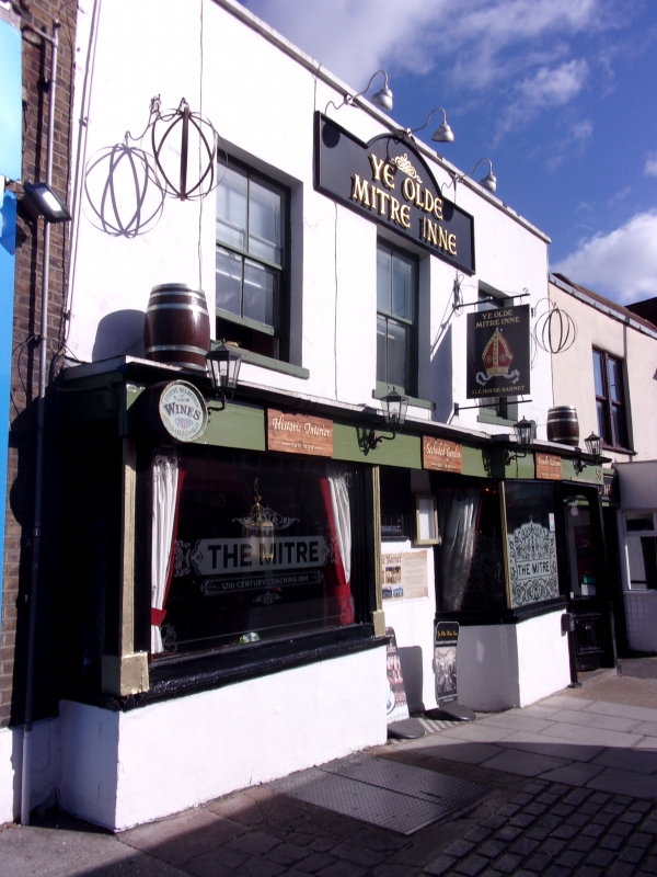
1.
5004 HIGH STREET
Barnet
No 58
(The Mitre Public House)
TQ 2496 10/29
II GV
2.
C17, timber framed. Refronted C19 and stuccoed. Three window, 2 storey. Double
bay window to ground storey. Good etched glass.
Listing NGR: TQ2466096458
External links are from the relevant listing authority and, where applicable, Wikidata. Wikidata IDs may be related buildings as well as this specific building. If you want to add or update a link, you will need to do so by editing the Wikidata entry.


Other nearby listed buildings
