Approximate Location Map
Large Map »
Latitude: 50.6835 / 50°41'0"N
Longitude: -3.2358 / 3°14'8"W
OS Eastings: 312792
OS Northings: 87821
OS Grid: SY127878
Mapcode National: GBR P8.XMS4
Mapcode Global: FRA 4738.H7F
Plus Code: 9C2RMQM7+9M
Entry Name: Toll House
Listing Date: 12 October 1951
Grade: II
Source: Historic England
Source ID: 1287706
English Heritage Legacy ID: 401621
ID on this website: 101287706
Location: New Town, East Devon, EX10
County: Devon
District: East Devon
Civil Parish: Sidmouth
Built-Up Area: Sidmouth
Traditional County: Devon
Lieutenancy Area (Ceremonial County): Devon
Church of England Parish: Salcombe Regis St Mary and St Peter
Church of England Diocese: Exeter
Tagged with: Tollhouse
SALCOMBE ROAD
1.
1633
(North Side)
Toll House
SY 1287 1/116 12.10.51.
II GV
2.
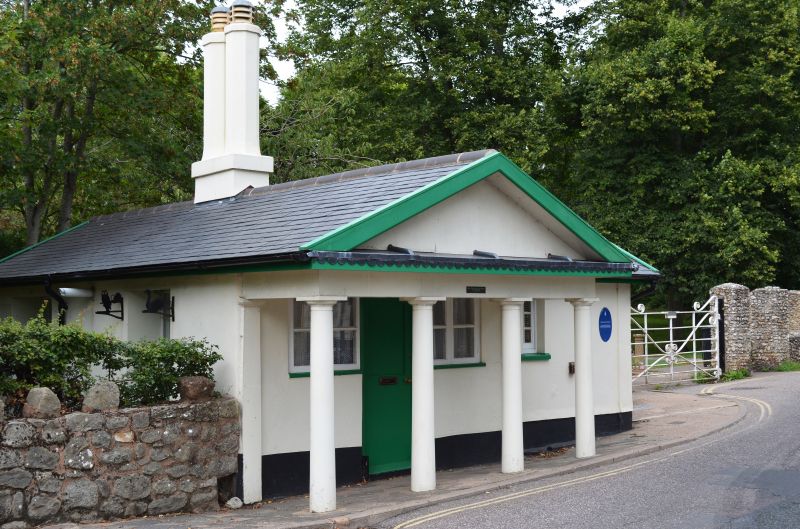
Low single storey stuccoed toll house. 3 bay Doric portico with pediment.
Slate roof. Tall paired octagonal chimneys. 3 casement windows altered.
Probably built at the some time as the Bridge.
The Bridge and Toll House form a good group.
Listing NGR: SY1279287821
External links are from the relevant listing authority and, where applicable, Wikidata. Wikidata IDs may be related buildings as well as this specific building. If you want to add or update a link, you will need to do so by editing the Wikidata entry.


Other nearby listed buildings
